
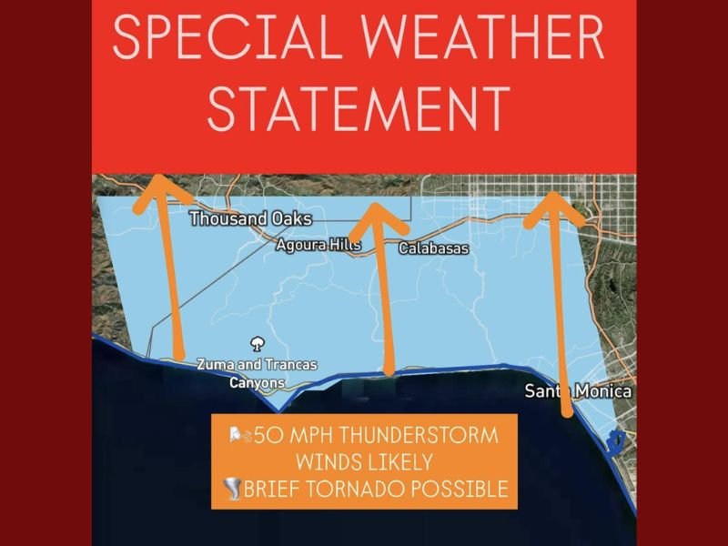
Southern California Storm Brings 50 MPH Winds and Possible Tornado Near Thousand Oaks and Calabasas
LOS ANGELES COUNTY, Calif. — A powerful coastal storm rolled onshore early Friday morning, prompting a Special Weather Statement for parts of Southern California, including Thousand Oaks, Agoura Hills, Calabasas, and Santa Monica. The system is capable of producing winds up to 50 mph, waterspouts over the Pacific, and even a brief tornado as it tracks inland through the morning hours.
The National Weather Service (NWS) issued the alert just before 6:00 a.m. Pacific Time, warning residents along the Los Angeles County coast and foothills to remain alert for fast-moving thunderstorms that could quickly intensify.
“This is a highly dynamic coastal storm capable of strong winds and rotation,” forecasters said early Friday. “Localized damage and power outages are possible as it moves inland.”
Storm Overview: Waterspouts to Inland Rotation
The storm system developed overnight off the Southern California coastline, fueled by a surge of moist Pacific air colliding with colder air aloft.
As the system moved toward the shore, meteorologists observed rotating thunderstorm cells capable of producing waterspouts over the ocean, which may evolve into brief, weak tornadoes as they reach land.
Affected communities include:
- Thousand Oaks
- Agoura Hills
- Calabasas
- Zuma and Trancas Canyons
- Santa Monica and parts of the coastal strip extending toward Malibu
Forecasters cautioned that while the risk of a tornado remains isolated and brief, the potential for damaging straight-line winds and localized flash flooding remains elevated.
50 MPH Wind Gusts and Thunderstorm Threat
Wind gusts up to 50 mph are likely across the region through mid-morning, particularly along elevated terrain and canyon areas.
Residents in Calabasas, Malibu Canyon, and Santa Monica Mountains should expect sudden bursts of wind capable of downing small tree limbs, knocking over unsecured outdoor items, and briefly disrupting power lines.
Accompanying thunderstorms may also produce:
- Small hail and intense lightning strikes
- Rapid rainfall bursts of up to 0.5 inches per hour
- Waterspouts or funnel clouds along the immediate coast
The NWS said these conditions are typical of a late-autumn Pacific storm, which combines both tropical moisture and sharp cold fronts to create unstable air over the ocean and near-shore areas.
Timeline of Expected Impacts
- 5:30–7:30 a.m.: The strongest thunderstorm cells move from Santa Monica Bay inland toward Thousand Oaks and Agoura Hills, with the potential for short-lived rotation.
- 7:30–10:00 a.m.: Showers and gusty winds continue across Calabasas and San Fernando Valley, weakening as the system pushes northward.
- Late morning to early afternoon: Conditions gradually improve, though scattered showers may linger across coastal Los Angeles County.
By midday, the storm is expected to lose strength as it interacts with drier inland air.
Officials Urge Caution
Local authorities are urging residents to stay indoors during periods of strong wind and lightning, and to avoid coastal waters where waterspouts may still form.
Drivers along Pacific Coast Highway (PCH) and Highway 101 should expect reduced visibility, slick roads, and possible debris from high winds.
“Even a short-lived tornado or 50 mph gust can cause damage or hazards on the road,” officials said. “Stay alert and don’t try to record severe weather from your vehicle.”
Emergency management agencies are also monitoring burn scar areas near the Santa Monica Mountains, where sudden downpours could trigger minor debris flows or mudslides.
Outlook: Calmer Conditions Ahead
Forecasters expect conditions to stabilize later Friday as the storm exits toward the northeast. However, another Pacific low-pressure system could approach the region early next week, potentially bringing additional rain and gusty winds.
Meteorologists say this early-season activity may signal an active winter storm pattern for Southern California, following a relatively quiet fall.
Residents should continue monitoring weather alerts from the National Weather Service and local emergency channels throughout the day for real-time updates.
Have you seen the storm near Calabasas or Thousand Oaks? Share your photos and updates with NapervilleLocal.com’s Weather Desk.

I’ve lived in Naperville long enough to see how quickly our community changes — from new developments downtown to sudden shifts in our Midwest weather. Reporting on Naperville news and daily forecasts gives me the chance to keep neighbors informed about what really matters. My goal is simple: deliver clear, timely updates so you always know what’s happening in our city and what to expect from the skies above.