
Southern California’s Bear Mountain Sees Early Snowfall As Colder System Brings Up to a Foot of Snow to San Bernardino Peaks
BIG BEAR LAKE, Calif. — Winter made an early appearance in Southern California this weekend as Bear Mountain woke up to a dusting of snow — with forecasters warning that a stronger, colder system arriving Monday could drop up to a foot of snow across the San Bernardino Mountains.
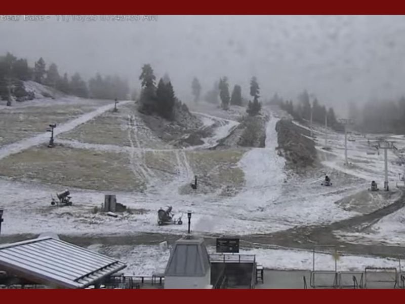
The snowfall, visible on Bear Mountain’s live cameras Sunday morning, marks one of the first measurable snow events of the season for the region, signaling a notable shift toward colder, more active weather patterns across the Southwest.
Light Snowfall Arrives Early Sunday at Bear Mountain
Just after sunrise, light snow began falling across the ski slopes at Bear Mountain and Snow Summit, creating a thin white layer that covered grassy trails and rooftops. The early snow was part of a weak frontal system that moved through Southern California overnight, bringing cold air and light precipitation to higher elevations above 6,000 feet.
By mid-morning, the National Weather Service (NWS) San Diego confirmed the snow activity and warned of much more on the way.
“It’s snowing at Bear this morning in Southern California!” meteorologists reported. “The next, colder system arrives tomorrow bringing up to a foot of snow for the highest peaks of the San Bernardino Mountains.”
Webcam images from the Bear Mountain base area showed light snow accumulation along the ski runs, with low clouds and fog limiting visibility at times.
Colder Pacific System Expected to Intensify Monday
Forecasters say a second, stronger Pacific system will move into the region late Sunday night into Monday, delivering colder air, gusty winds, and heavier mountain snow.
The heaviest accumulations are expected above 7,000 feet, including Big Bear Lake, Running Springs, and the highest portions of the San Gorgonio Wilderness.
“The upcoming system will be much colder,” said NWS meteorologist Alex Tardy. “We could see 6 to 12 inches of snow at the highest elevations, with locally higher totals possible along ridge lines.”
Lower elevations between 5,000 and 6,000 feet may see light snow or a rain/snow mix, while valley areas will stay cold and mostly dry.
The colder air mass behind the system is expected to drop temperatures by 15 to 20 degrees compared to last week’s highs, with daytime readings in the 30s and 40s across the San Bernardino Mountains.
Travel Impacts Likely for Mountain Passes
The storm is expected to make travel hazardous across key mountain routes, including Highway 18, Highway 38, and Highway 330, where chain controls may be required by Monday morning.
The California Highway Patrol (CHP) is urging drivers to check weather conditions before heading up to the mountains and to carry snow chains, blankets, and emergency supplies.
“If you’re traveling to or from Big Bear Monday, plan ahead,” CHP officials said. “Expect slick roads, low visibility, and delays during heavier snow periods.”
Wind gusts could reach 40 mph along ridges and exposed slopes, adding to the risk of blowing snow and reduced visibility.
Good News for Ski Resorts and Winter Recreation
While the storm may cause short-term travel headaches, it’s a welcome sight for Southern California’s ski industry, which has been preparing for the winter season.
Both Bear Mountain and Snow Summit—part of the Big Bear Mountain Resort network—have been running snowmaking operations at night, and natural snowfall will help accelerate base buildup ahead of the holidays.
Resort officials say this early storm, paired with consistent cold temperatures forecasted through Thanksgiving week, could allow for earlier-than-expected terrain openings.
“This is exactly what we needed,” one resort operator said. “It’s setting up perfectly for Thanksgiving skiing if the pattern holds.”
The San Bernardino Mountains typically receive their first major snowfall in late November or early December, but this early accumulation bodes well for water supply levels and winter recreation.
Extended Outlook: More Systems on the Horizon
Meteorologists say the active pattern across the West isn’t going away anytime soon. Long-range forecasts show another potential storm system arriving later in the week, possibly bringing another round of snow to Southern California’s higher terrain.
Meanwhile, other Western states — including California’s Sierra Nevada, Utah, and Colorado — are also gearing up for multiple rounds of mountain snow as a Pacific storm train develops into Thanksgiving week.
“This pattern favors back-to-back systems,” NWS forecasters said. “We could see two or three more snow events before the end of the month, especially across the Southwest mountains.”
Residents Urged to Prepare for Cold Weather
With the first snow already on the ground and more on the way, forecasters urge Southern Californians to prepare for cold mornings, possible frost, and winter driving conditions in higher elevations.
Homeowners in mountain communities are advised to protect pipes, bring pets indoors, and check heating systems as temperatures continue to plunge.
Do you live near Big Bear or plan to visit the San Bernardino Mountains this week? Share your photos and weather reports with NapervilleLocal.com as Southern California welcomes its first major taste of winter.

I’ve lived in Naperville long enough to see how quickly our community changes — from new developments downtown to sudden shifts in our Midwest weather. Reporting on Naperville news and daily forecasts gives me the chance to keep neighbors informed about what really matters. My goal is simple: deliver clear, timely updates so you always know what’s happening in our city and what to expect from the skies above.