
Southern Plains Enter Extended Dry Spell as Subtropical Jet Stream Weakens, Warmer Temperatures Expected Mid-December
OKLAHOMA CITY, OKLAHOMA — The Southern Plains are heading into a prolonged dry pattern as the subtropical jet stream weakens, cutting off the region’s main source of precipitation for the next week to 10 days. Weather models indicate that little to no measurable rainfall is expected across Texas, Oklahoma, and parts of Kansas, even as a few dry cold fronts sweep through in the coming days.
According to new CPC and Pivotal Weather data, the atmospheric setup is shifting toward a “feast or famine” phase — a pattern characterized by extended dry stretches followed by abrupt warm-ups. This upcoming dry spell could persist through at least December 14, with high pressure dominating much of the South-Central U.S.
Dry Cold Fronts First, Then a Significant Warm-Up
Forecasters say a few weak fronts will pass through early in the period, briefly reinforcing cooler air without bringing precipitation. These fronts will mainly impact northern Texas, central Oklahoma, and southern Kansas, where daytime highs will stay in the 50s and lower 60s through the weekend.
By mid to late next week, however, a significant warming trend will take hold as the subtropical ridge rebuilds. Temperatures are projected to rise into the mid-60s and low 70s across much of the Southern Plains, including cities like Dallas, Oklahoma City, and Lubbock.
“We’re entering one of those classic early winter lulls where the jet stream relaxes and storms track far to the north,” said meteorologist Jeff Hovorka. “The trade-off is dry, mild days — great for travel, not great for soil moisture.”
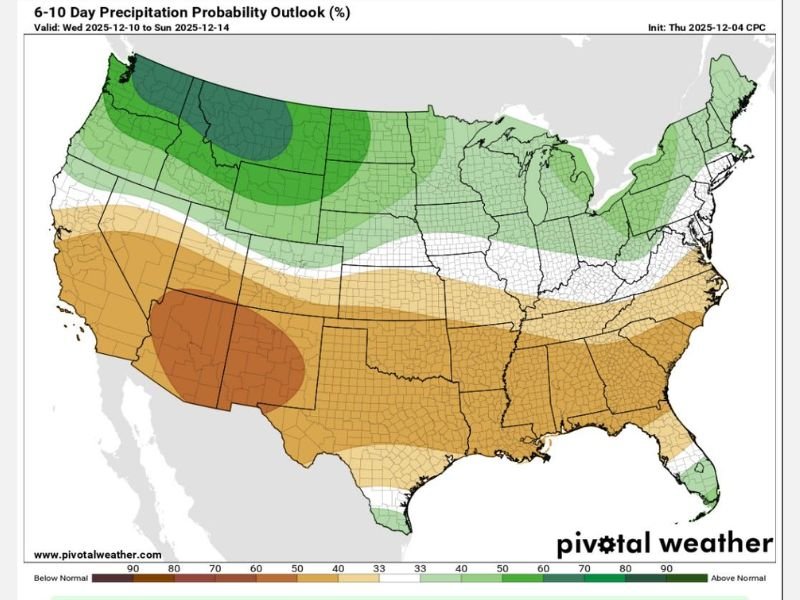
Precipitation Outlook: Below Normal for Southern U.S.
The 6–10 Day Precipitation Probability Outlook from the Climate Prediction Center (CPC) shows a large swath of below-average precipitation stretching from New Mexico and Texas eastward through the Gulf States and into Georgia.
- Texas and Oklahoma: 70–90% chance of below-normal rainfall.
- Arkansas and Louisiana: 60–70% below-average precipitation likely.
- Pacific Northwest and Northern Rockies: The only regions expecting above-normal rainfall during this same period.
This dry setup is tied to a weakened subtropical jet stream, which typically delivers moisture-laden systems from the Pacific into the southern U.S. When that jet quiets, storm activity decreases dramatically across the region.
Farmers and Ranchers Face Moisture Deficit
While the dry weather may be welcomed by travelers and construction crews, agricultural experts are watching closely. Soil moisture levels in parts of the Southern Plains and West Texas are already below seasonal averages. Prolonged dryness could hinder winter wheat conditions and limit early-season pasture growth.
“This is a critical stretch for soil moisture retention,” said agronomist Rachel Thornton with the Oklahoma Mesonet. “If we don’t see rain soon, some areas could enter moderate drought before the end of December.”
Mid-December Outlook: Mild Pattern Holds
After next week’s warm-up, models suggest the mild, dry pattern could persist through at least mid-December, with above-average temperatures expanding eastward into the Lower Mississippi Valley.
The CPC’s long-range temperature outlook favors highs 10–15°F above normal, signaling one of the warmest mid-December periods in recent years for parts of Texas, Oklahoma, and Louisiana.
Still, forecasters caution that with the jet stream “asleep,” the next active weather pattern may arrive abruptly once it reawakens — potentially in the second half of December.
Stay informed on changing weather patterns and forecast updates for your region at NapervilleLocal.com.

I’ve lived in Naperville long enough to see how quickly our community changes — from new developments downtown to sudden shifts in our Midwest weather. Reporting on Naperville news and daily forecasts gives me the chance to keep neighbors informed about what really matters. My goal is simple: deliver clear, timely updates so you always know what’s happening in our city and what to expect from the skies above.