
Strong Arctic Cold Front May Set the Stage for a Widespread Texas Winter Weather Event Next Weekend
TEXAS — Forecast guidance is signaling a potentially impactful winter weather setup across Texas next weekend, as a strong Arctic cold front pushes south and is followed closely by a moisture-rich system spreading precipitation across the state.
While this scenario is still about six days out, the overall pattern is becoming increasingly noticeable and worth close monitoring, especially for those planning travel or outdoor activities next weekend.
Cold Air Arrival Followed by Widespread Moisture
Model projections show a classic winter setup beginning with a sharp cold frontal passage, allowing colder air to drain southward across Texas. Shortly after the frontal passage, an incoming system is expected to spread moisture from west to east, creating an environment supportive of winter precipitation.
This overlap between cold air at the surface and incoming moisture aloft is a key ingredient for wintry weather development.
Rain, Wintry Mix, and Snow All Possible Across Texas
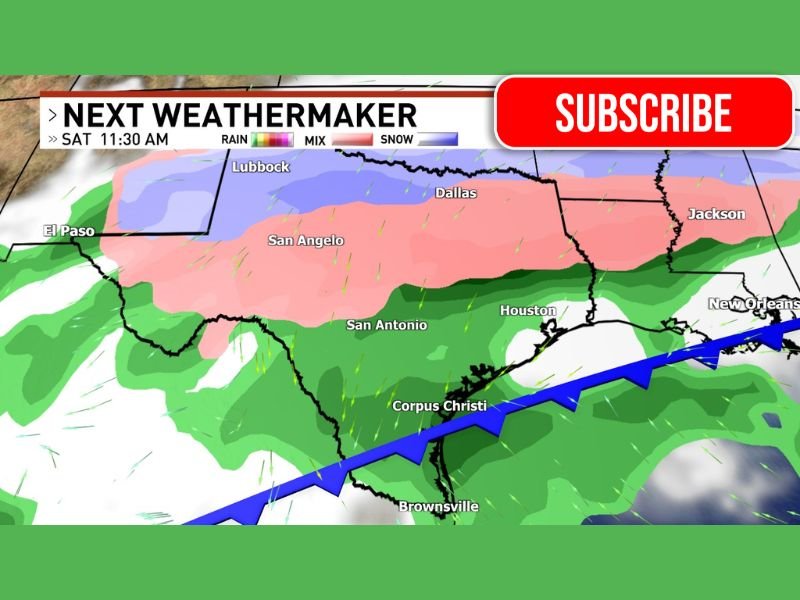
Based on the current modeling signal:
- Southern Texas, including coastal areas, appears more likely to see cold rain
- Central Texas, including areas near San Antonio and Dallas, could be positioned for a wintry mix
- Northern and western Texas, including the Panhandle and parts of West Texas, show potential for snowfall
The exact placement of these zones will likely shift in the coming days, but the presence of all three precipitation types highlights the complexity of this setup.
Still Too Early for Exact Impacts and Timing
At this range, specific snowfall totals, ice accumulations, and timing cannot be pinned down with confidence. Small changes in the track of the system or the strength of the cold air could significantly alter outcomes.
However, the fact that multiple model solutions are consistently developing a winter signal suggests this is no longer a long-range fantasy scenario.
Why This Pattern Deserves Attention
Texas has largely avoided significant winter weather so far, which makes this setup notable. The combination of:
- A strong cold front
- Sustained cold air drainage
- An incoming moisture-laden system
raises the potential for impactful winter conditions, especially if colder air arrives faster or lingers longer than currently expected.
Bottom Line
While details will continue to evolve, next weekend is shaping up as a legitimate winter weather window for Texas. Confidence is increasing that some portion of the state could experience snow, ice, or a wintry mix, making this a forecast worth watching closely over the coming days.
For continued updates, clear breakdowns, and no-hype weather explanations as this forecast evolves, stay connected with NapervilleLocal.com.

I’ve lived in Naperville long enough to see how quickly our community changes — from new developments downtown to sudden shifts in our Midwest weather. Reporting on Naperville news and daily forecasts gives me the chance to keep neighbors informed about what really matters. My goal is simple: deliver clear, timely updates so you always know what’s happening in our city and what to expect from the skies above.