
Strong Arctic Cold Front to Bring Sunday Morning Lows in the Teens and 20s Across Oklahoma and North Texas as Wind Chills Drop Even Lower
Oklahoma City, Oklahoma — A strong Arctic cold front moving into the Southern Plains is expected to deliver the coldest temperatures of the season to Oklahoma and North Texas by early Sunday morning. Forecast maps show widespread lows in the teens and 20s, accompanied by 30 mph wind gusts that will push wind chills roughly 10 degrees colder.
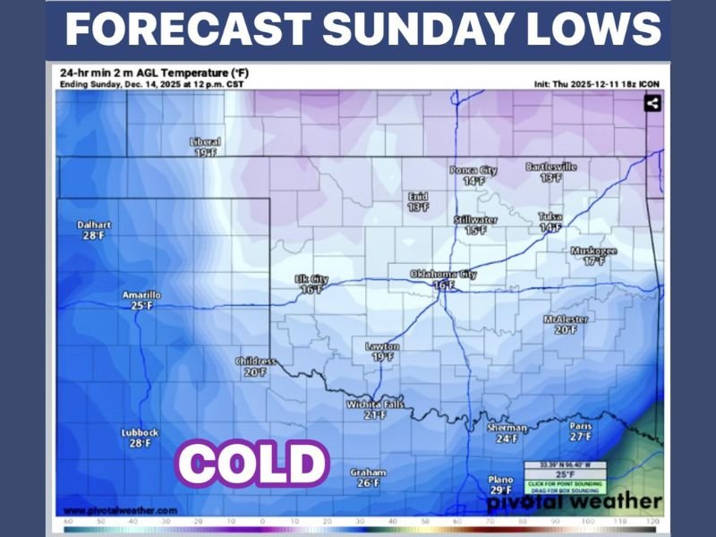
Widespread Teens and 20s Expected Across Oklahoma
Forecast data from the National Weather Service shows that cities across Oklahoma will begin Sunday with dangerously cold morning lows, including:
- Ponca City: 14°F
- Bartlesville: 13°F
- Enid: 18°F
- Stillwater: 15°F
- Tulsa: 14°F
- Muskogee: 17°F
- Oklahoma City: 16°F
- Lawton: 19°F
- McAlester: 20°F
With north winds gusting up to 30 mph, many locations will feel closer to the single digits, prompting meteorologists to warn that residents should prepare for harsh outdoor conditions.
North Texas to See Hard Freeze Conditions
The colder air will extend well into North Texas, where several communities are forecast to drop into the low to mid-20s. Projected lows include:
- Wichita Falls: 21°F
- Graham: 26°F
- Sherman: 24°F
- Paris: 27°F
- Plano: 29°F
Even areas closer to the Red River will experience a freeze, marking a significant shift from earlier mild December conditions.
Forecasters emphasize that wind chills will be even colder, raising concerns for those traveling early or working outdoors.
Residents Urged to Protect Pets, Plants, and Pipes
Local officials are encouraging residents across Oklahoma and North Texas to take protective measures ahead of the cold blast. Experts recommend:
- Bringing pets indoors
- Covering outdoor faucets
- Wrapping vulnerable pipes
- Protecting sensitive plants
- Allowing extra commute time due to potential frost and freezing spots
Temperatures are expected to remain cold into Monday morning, which could bring an even sharper drop in some locations.
Cold Front Marks Start of a Broader Pattern Shift
Meteorologists report that the arriving Arctic front is part of a larger regional pattern that will send colder air deeper into the central and southern United States through early next week. While conditions will gradually moderate later in the week, early-morning cold will persist.
For continuing updates on temperature forecasts and weather impacts across the region, visit NapervilleLocal.com.

I’ve lived in Naperville long enough to see how quickly our community changes — from new developments downtown to sudden shifts in our Midwest weather. Reporting on Naperville news and daily forecasts gives me the chance to keep neighbors informed about what really matters. My goal is simple: deliver clear, timely updates so you always know what’s happening in our city and what to expect from the skies above.