
Strong Arctic Cold Front to Slam Into North Texas With Rapid Temperature Drop, Gusty Winds, and Widespread Freezes Through Tuesday
TEXAS — A strong Arctic cold front is expected to surge into North Texas by mid-afternoon, turning warm conditions sharply colder as temperatures fall rapidly into Sunday evening. Forecast data shows winds gusting to 45 mph and a small chance of showers along the leading edge of the front, followed by a quick plunge into freezing temperatures by early Monday morning.
Meteorologists say the dramatic shift will mark one of the most significant temperature drops of the season so far, especially after parts of North Texas climbed near 80 degrees earlier in the day. Once the front passes, cold air will deepen across the region and linger through the start of the week.
Rapid Temperature Drop After a Near-80° Afternoon
The incoming cold front will cut off the unusually warm air mass currently in place across North Texas. Temperatures that reached the upper 70s to near 80 earlier today will tumble rapidly as the front sweeps through, with evening readings expected to fall into the 30s.
By Monday morning, much of the region will reach a light freeze, and forecasters note that wind chills will feel about 10 degrees colder, dropping into the 20s for many areas. Some locations closer to the Red River may experience teens, especially where winds remain elevated overnight.
Cold, gusty air behind the front will make outdoor conditions uncomfortable through Monday morning and afternoon.
Temperatures Hold in the 40s All Day Monday
Following the overnight freeze, temperatures on Monday are expected to remain stuck in the 40s all day, despite sunny skies developing behind the front. This will create a distinctly winter-like feel across North Texas, far removed from today’s warm and breezy conditions.
Monday night into Tuesday morning brings an even more widespread freeze, with forecast lows falling into the 20s across most of the region. Strong north winds will gradually weaken but may still produce biting wind chills for early commuters and school drop-off hours. This extended period of cold will mark the most prolonged chill of the week before temperatures slowly recover mid-week.
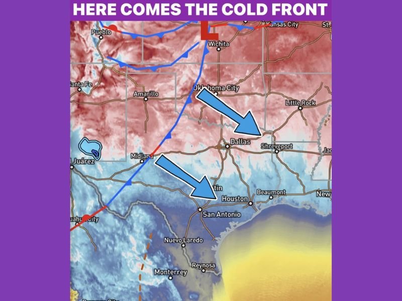
Cold Air Extends Well South Toward Central and Coastal Texas
Model imagery shows the Arctic air mass pushing well beyond Dallas–Fort Worth, spreading south into Austin, Houston, and San Antonio. The map highlights deep blue shading across nearly the entire state, signaling just how far the cold surge will reach by late tonight.
Although southern Texas will not experience temperatures as cold as the northern counties, residents should still expect a significant cooldown compared to recent conditions. Many locations may see wind chills in the 30s Monday morning, with some areas briefly dropping into the upper 20s. This broad reach of cold air may lead to isolated impacts on sensitive vegetation, outdoor pets, and unprotected pipes—especially in rural communities.
Residents Urged to Prepare for Freezing Conditions
As temperatures fall rapidly, officials recommend securing outdoor items, protecting exposed pipes, and bringing pets indoors for the next several nights. Drivers should be cautious during the early morning hours, particularly in areas experiencing stronger wind chills or patchy light freezing conditions.
NapervilleLocal.com will continue monitoring this Arctic intrusion and the evolving temperature trends across Texas. Check back for updates, deeper analysis, and extended forecasts as the state moves into a colder start to the week.

I’ve lived in Naperville long enough to see how quickly our community changes — from new developments downtown to sudden shifts in our Midwest weather. Reporting on Naperville news and daily forecasts gives me the chance to keep neighbors informed about what really matters. My goal is simple: deliver clear, timely updates so you always know what’s happening in our city and what to expect from the skies above.