
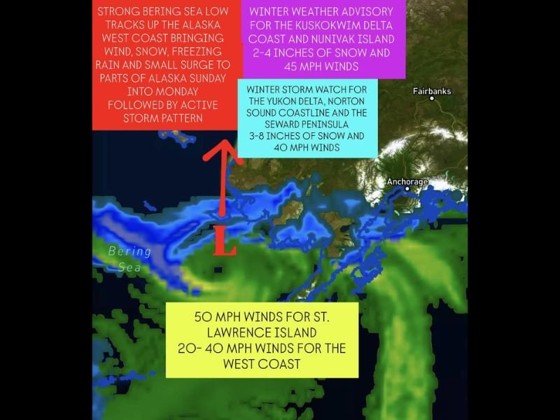
Strong Bering Sea Storm to Bring High Winds, Snow, and Freezing Rain to Western Alaska Through Monday
ANCHORAGE, Alaska — A strong low-pressure system from the Bering Sea is expected to impact much of Western Alaska through Sunday night into Monday, bringing high winds, snow, freezing rain, and coastal surges to several regions including the Aleutians, Alaska Peninsula, Bristol Bay Coast, and Kuskokwim Delta.
Meteorologists warn that this developing storm will track northward from the Bering Sea, driving a potent mix of winter weather that could cause travel disruptions, reduced visibility, and localized flooding near coastal areas.
Heavy Winds and Snow Spread Across Alaska’s West Coast
The National Weather Service says the system will first hit the Eastern Aleutians and Alaska Peninsula, where gusty winds and rain will arrive late Sunday. As the storm intensifies and pushes inland, the precipitation is expected to transition into snow and freezing rain, especially across the Yukon-Kuskokwim Delta and Western Capes.
“This storm won’t reach the extreme strength of previous systems like Typhoon Halong,” forecasters said, “but it will still bring dangerous conditions, especially for coastal and air travel.”
Snow accumulations will vary by region, but the Seward Peninsula and Norton Sound Coastline could see between 3 to 8 inches of snow, with winds reaching up to 40 mph. The Kuskokwim Delta Coast and Nunivak Island are forecast to receive 2 to 4 inches of snow along with 45 mph winds that may produce blowing snow and whiteout conditions.
Winter Storm Watches and Advisories Issued
Several weather alerts are now in effect across western and southwestern Alaska:
- Winter Weather Advisory: Kuskokwim Delta Coast & Nunivak Island – 2–4 inches of snow, winds up to 45 mph.
- Winter Storm Watch: Yukon Delta, Norton Sound Coastline & Seward Peninsula – 3–8 inches of snow, 40 mph winds.
- Wind Advisory: St. Lawrence Island & West Coast – Winds 20–50 mph expected Sunday night through Monday.
Officials note that coastal surge risks remain “low to moderate”, but some areas may experience minor flooding depending on wind direction and tide timing.
Storm Impacts: Freezing Rain, Coastal Surge, and Travel Delays
As the Bering Sea low tracks northeastward, temperatures will fluctuate sharply, causing snow to shift temporarily into freezing rain before changing back to snow by Monday evening.
This mix of precipitation could lead to icy road conditions and power interruptions across communities along the Alaska Peninsula, Bristol Bay Coast, and Kuskokwim Delta.
“Drivers should prepare for slick conditions and rapidly changing visibility,” said a meteorologist from the NWS Alaska Region. “Even a brief period of freezing rain could create hazardous ice buildup.”
In addition, small vessel operators and coastal residents are urged to use caution as gusts of 50 mph could generate rough seas and localized flooding in low-lying coastal areas.
Arctic Pattern Behind the Storm
The current weather system is part of a larger active storm pattern developing over the northern Pacific and Arctic regions. Forecasters say strong jet stream activity is helping funnel warm, moist air into the Bering Sea, clashing with cold Arctic air masses over Western Alaska — a setup that often triggers intense low-pressure systems like this one.
While the upcoming storm won’t mirror the destructive coastal surge caused by Typhoon Halong’s remnants last year, meteorologists caution that late November will remain storm-active, with additional systems expected to track into the region before Thanksgiving.
Residents Urged to Stay Alert
Emergency officials are urging residents in coastal and delta communities to secure outdoor items, check travel plans, and stay informed about the latest weather alerts through the National Weather Service Alaska Region.
Communities across the Yukon Delta, the Seward Peninsula, and the Aleutians should also be prepared for temporary power outages and flight delays as strong winds and mixed precipitation continue through Monday.
“This is a typical November Bering Sea storm pattern,” the NWS said in its evening bulletin. “While not extreme, it reinforces the need for preparedness and awareness as winter deepens across the state.”
Looking Ahead
The storm is expected to weaken gradually by Tuesday, with lingering snow showers and winds slowly diminishing through midweek. However, forecasters say another active system could approach from the Pacific by late next week, bringing more snow and wind to Alaska’s western coast.
Residents should continue to monitor updated forecasts and stay weather aware through early next week.
Have you experienced early winter weather in your area yet? Share your updates and photos with us at NapervilleLocal.com.

I’ve lived in Naperville long enough to see how quickly our community changes — from new developments downtown to sudden shifts in our Midwest weather. Reporting on Naperville news and daily forecasts gives me the chance to keep neighbors informed about what really matters. My goal is simple: deliver clear, timely updates so you always know what’s happening in our city and what to expect from the skies above.