
Strong Cold Front Set to Push Across Texas With Wind Chills Dropping Into the 20s and 30s by Tuesday Morning
TEXAS — A strong and fast-moving cold front is expected to sweep across Texas later today, delivering a sharp temperature drop and widespread wind chills that will plunge into the 20s and 30s by early Tuesday morning. Forecast models show the cold air pushing steadily southward, eventually reaching southeast Texas sometime tomorrow as the front strengthens and expands across the state.
This incoming system marks a significant shift from the recent warm conditions many regions of Texas have experienced. Meteorologists warn residents to prepare for a sudden and noticeable change as temperatures fall quickly behind the advancing front.
Wind Chills in the 20s Expected Across North and Central Texas
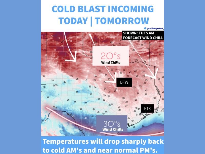
Model imagery indicates that cities across north and central Texas, including the Dallas–Fort Worth (DFW) region, will see wind chills dropping into the 20s by early Tuesday. These colder values are driven by strong northerly winds that will intensify once the front pushes through, making temperatures feel much colder than they actually are.
The broad area of darker shading on the map highlights how widespread this cold air mass will be. Much of northern and central Texas will feel the brunt of the Arctic push, creating cold mornings and brisk daytime conditions as the week begins.
Residents in these areas should be ready for windy and uncomfortable conditions, especially during early commutes.
Southeast Texas and Coastal Regions to See Wind Chills in the 30s
Farther south, cities such as Houston (HTX) and nearby coastal communities are expected to see wind chills in the 30s, still representing a major change from recent temperatures. While not as cold as the northern half of the state, the incoming front will still create noticeably chilly conditions along the Gulf Coast.
Forecast graphics show colder colors spreading all the way into coastal Texas, indicating that the cold air will not weaken significantly before reaching the shoreline. Morning lows will drop sharply, and even afternoon temperatures will settle closer to seasonal averages after the front passes.
Residents in southeast Texas should anticipate a chilly start to Tuesday, along with breezy winds that enhance the cold.
Sharp Temperature Drop Follows Early-Week Warmth
Meteorologists emphasize how abrupt the shift will feel. Warm daytime temperatures today will quickly give way to much colder air as the front arrives, creating a dramatic change within a short period. This type of strong frontal passage is common during winter months, especially when Arctic air moves rapidly southward.
The quick temperature decline combined with persistent winds will create uncomfortable outdoor conditions during both early and late hours of the day. Even without precipitation, the cold alone will influence daily routines across the state.
What Texans Should Expect as the Front Moves In
As the front pushes through, residents should plan for colder mornings, stronger winds, and lower visibility in open rural areas where blowing dust may occur. Pets, plants, and exposed pipes may need extra attention depending on local temperatures and wind speeds.
Although the front does not appear to bring significant rain or wintry precipitation, the cold wind chills will still impact travel, outdoor work, and early-morning activities across a wide portion of the state.
With colder air settling into Texas, NapervilleLocal.com will continue tracking updated forecasts and changing temperature trends. Check back for new information, deeper analysis, and ongoing coverage as additional winter systems begin developing in the coming days.

I’ve lived in Naperville long enough to see how quickly our community changes — from new developments downtown to sudden shifts in our Midwest weather. Reporting on Naperville news and daily forecasts gives me the chance to keep neighbors informed about what really matters. My goal is simple: deliver clear, timely updates so you always know what’s happening in our city and what to expect from the skies above.