
Strong Cold Front to Sweep Through North Georgia Thursday, Bringing Likely Thunderstorms and Possible Severe Risk from Atlanta to Asheville
GEORGIA — After the recent cold spell moves out, attention turns to Thursday, when a strong cold front is expected to sweep across north Georgia, bringing widespread thunderstorms and the potential for severe weather.
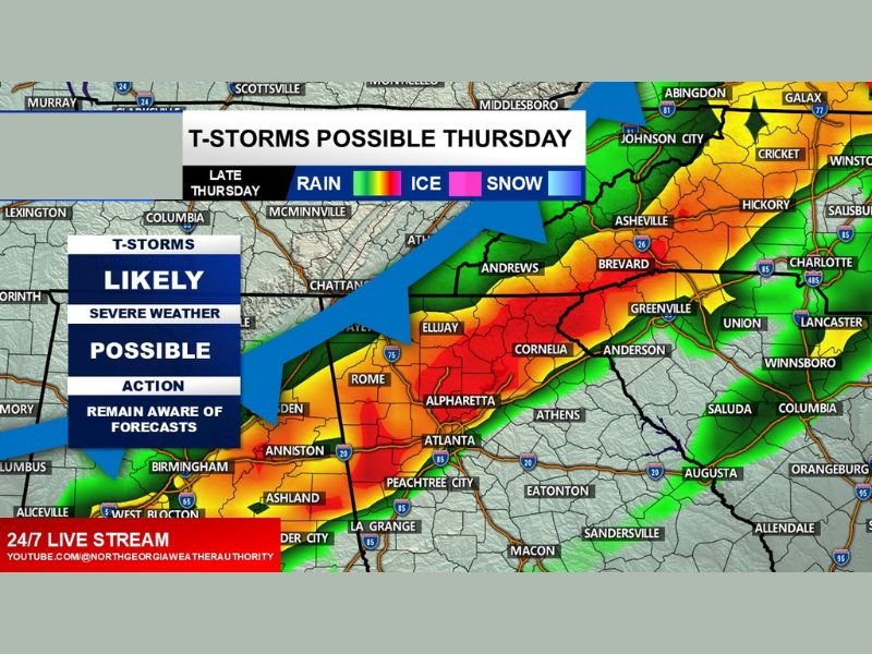
Temperatures ahead of the front will climb into the middle 60s, creating a warmer and more unstable environment compared to earlier in the week. Forecasters indicate that this setup could allow at least some overlap of instability and wind shear — two key ingredients for stronger storms.
Thunderstorms Likely Late Thursday
Forecast guidance shows thunderstorms becoming likely late Thursday as the front pushes eastward across the state. The most active weather appears positioned along a corridor stretching from Anniston, Alabama, through Atlanta, Alpharetta, and Cornelia, and extending northeast toward Asheville, North Carolina.
The map indicates a concentrated band of heavier storms tracking across:
- Rome
- Atlanta
- Alpharetta
- Cornelia
- Areas west toward the Alabama line
- Northeast toward western North Carolina
Heavy rainfall and gusty winds will be the primary concerns.
Severe Weather Possible, But Details Still Unclear
While thunderstorms are considered likely, the extent of severe weather remains uncertain. Meteorologists note that the exact placement and intensity of severe storms will depend on how much instability develops ahead of the front.
If instability and wind shear align sufficiently, some storms could become strong to severe. However, it is still too early to determine how widespread that threat may be or exactly which communities would be most impacted.
Residents in north Georgia, especially around metro Atlanta and the I-85 corridor, are advised to monitor updated forecasts as Thursday approaches.
Rain, Wind, and Temperature Shift
Ahead of the cold front, mild temperatures in the mid-60s will create a spring-like feel. Once the front passes, cooler air will filter back in.
Impacts to watch for include:
- Periods of heavy rain
- Gusty winds with stronger cells
- Lightning
- Rapid temperature changes after frontal passage
The overall system is expected to move fairly quickly, but timing will be important for commuters and anyone with outdoor plans Thursday evening.
Stay Weather Aware
With thunderstorms likely and at least a conditional severe risk in place, staying updated will be key. Forecast details, including timing and intensity, will become clearer as Thursday gets closer. For continued national storm coverage and regional weather updates, stay connected with NapervilleLocal.com.

I’ve lived in Naperville long enough to see how quickly our community changes — from new developments downtown to sudden shifts in our Midwest weather. Reporting on Naperville news and daily forecasts gives me the chance to keep neighbors informed about what really matters. My goal is simple: deliver clear, timely updates so you always know what’s happening in our city and what to expect from the skies above.