
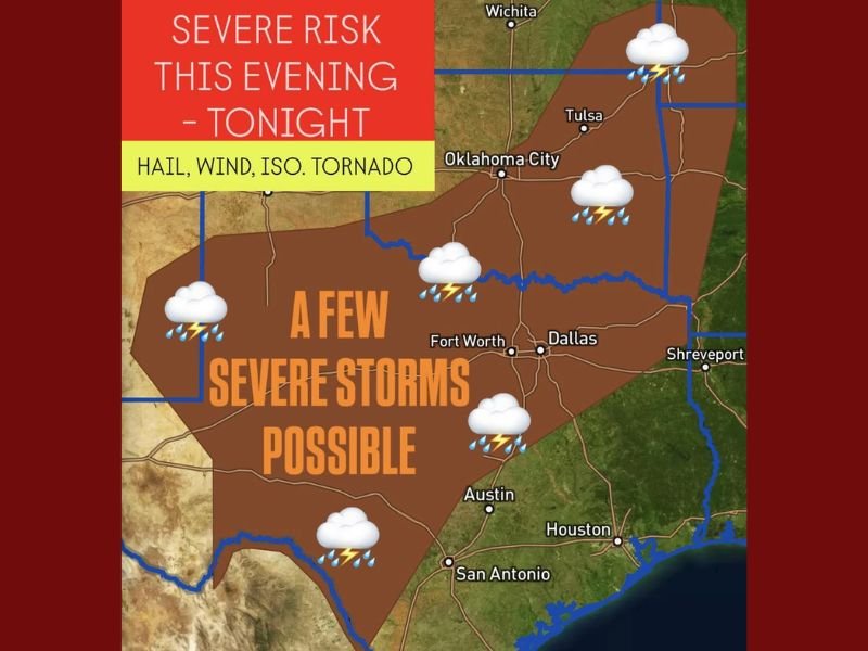
Strong Evening Storms Expected Across Texas and Oklahoma with Risk of Hail, Wind, and Isolated Tornadoes
DALLAS, TEXAS — A developing storm system is expected to bring strong to severe thunderstorms across portions of Texas, Oklahoma, and nearby states this evening through overnight hours.
Forecasters warn that storms could produce large hail, damaging wind gusts, and even a few isolated tornadoes, particularly in north and central Texas. Areas of southeast New Mexico, southeast Kansas, west Arkansas, and southwest Missouri are also under a marginal to slight risk for severe weather.
Severe Risk Expands Across Central and Southern Plains
According to weather outlook maps, a broad zone of severe potential stretches from Lubbock and Abilene eastward through Dallas-Fort Worth, Austin, and into Shreveport.
The main threat will be large hail and strong wind gusts, but meteorologists caution that a low-end tornado risk exists, particularly across central and north Texas late tonight.
“While widespread tornado activity isn’t expected, the setup does support a few rotating storms capable of producing brief tornadoes,” forecasters said.
Timing and Impacts
Storms will develop during the late evening hours and may continue overnight into early Wednesday, bringing bursts of heavy rain and frequent lightning. The most active window for severe weather will be between 7 p.m. and 2 a.m., when the strongest cells are expected to organize along the advancing cold front.
Motorists traveling along Interstates 35 and 20 should be prepared for sudden drops in visibility, slick roads, and gusty crosswinds during the height of the storms.
Safety Precautions
Residents across Texas and Oklahoma are advised to remain weather-aware throughout the evening and ensure they have multiple ways to receive warnings overnight.
Authorities urge residents to:
- Stay indoors during storms and avoid travel when possible.
- Move vehicles to covered areas to protect against hail damage.
- Keep mobile alerts or NOAA weather radios on in case tornado warnings are issued.
The severe weather threat will shift eastward into Arkansas and Louisiana by early Wednesday, with drier and cooler conditions following behind the front.
Stay tuned for updates on changing conditions and local advisories at NapervilleLocal.com.

I’ve lived in Naperville long enough to see how quickly our community changes — from new developments downtown to sudden shifts in our Midwest weather. Reporting on Naperville news and daily forecasts gives me the chance to keep neighbors informed about what really matters. My goal is simple: deliver clear, timely updates so you always know what’s happening in our city and what to expect from the skies above.