
Strong Friday Morning Frontal Line Triggers Heavy Rain Across Alabama, Georgia and the Carolinas — Florida Watching to See How Much Makes It South
UNITED STATES — A vigorous frontal boundary is energizing weather across the Deep South this morning, producing a broad swath of moderate to heavy rainfall stretching from Louisiana through Alabama, Georgia, and into the Carolinas.
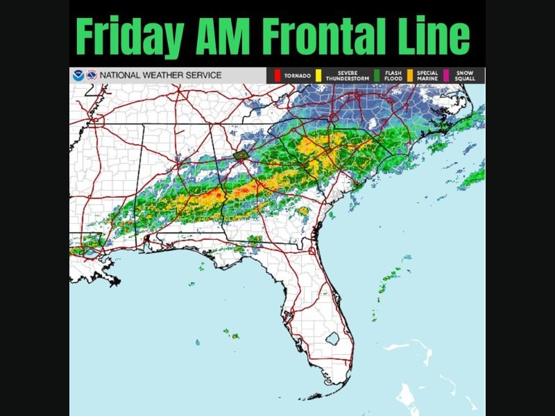
Early radar imagery shows the most organized band of rain running west-to-east across southern Mississippi, southern Alabama, central Georgia, and into South and North Carolina, with embedded heavier downpours.
Where the Heaviest Rain Is Right Now
The strongest returns early this morning are focused across:
- Southern Alabama
- Central and southern Georgia
- Southern Mississippi
- Upstate South Carolina
- Southern North Carolina
Pockets of heavier rainfall are embedded within the broader rain shield, especially across central Alabama and western Georgia. The band is gradually sagging southward as the front advances.
Meanwhile, lighter precipitation extends northward into parts of Tennessee and northern Georgia, with colder air visible farther north in the Mid-Atlantic.
Will Florida See the Heavier Rain?
One key question today is how much of this organized rainfall survives its southward push into Florida.
At this stage, much of the heaviest activity remains across Alabama and Georgia. As the frontal boundary continues moving, some rain is expected to reach northern Florida later today. However, it remains uncertain how much intensity will hold together by the time it arrives.
Middle States May Get the Most
Forecast trends suggest the corridor from central Alabama through Georgia and into the Carolinas may receive the most substantial rainfall totals as the system matures later today and into Saturday.
By Saturday, the frontal zone continues shifting east and southeast, gradually weakening.
Clearing Expected by Sunday
The good news for the region: conditions are expected to improve by Sunday as the system clears out.
Behind the front, drier air filters in, allowing skies to brighten and rainfall to taper off across the Southeast.
What to Expect
- Heavy rain bands across Alabama, Georgia, and the Carolinas Friday morning
- Southward progression toward Florida later today
- Greatest rainfall focus across central portions of the Southeast
- Gradual clearing and improving conditions by Sunday
Residents across the Southeast should monitor localized heavy rainfall and allow extra travel time during stronger downpours.
For continued national and regional weather updates, stay connected with NapervilleLocal.com.

I’ve lived in Naperville long enough to see how quickly our community changes — from new developments downtown to sudden shifts in our Midwest weather. Reporting on Naperville news and daily forecasts gives me the chance to keep neighbors informed about what really matters. My goal is simple: deliver clear, timely updates so you always know what’s happening in our city and what to expect from the skies above.