
Strong Pacific Storm System to Bring Heavy Rain, Severe Thunderstorms, and a Cold Front Across Texas Midweek
TEXAS — Forecasters are tracking a powerful Pacific storm system that’s expected to move into Texas by midweek, bringing the potential for heavy rain, thunderstorms, and severe weather on Wednesday and Thursday (Nov. 19–20).
Meteorologists from KXAN’s First Warning Weather Team report increasing confidence that this storm will sweep across much of the state, followed by a strong cold front capable of dropping temperatures sharply behind the system.
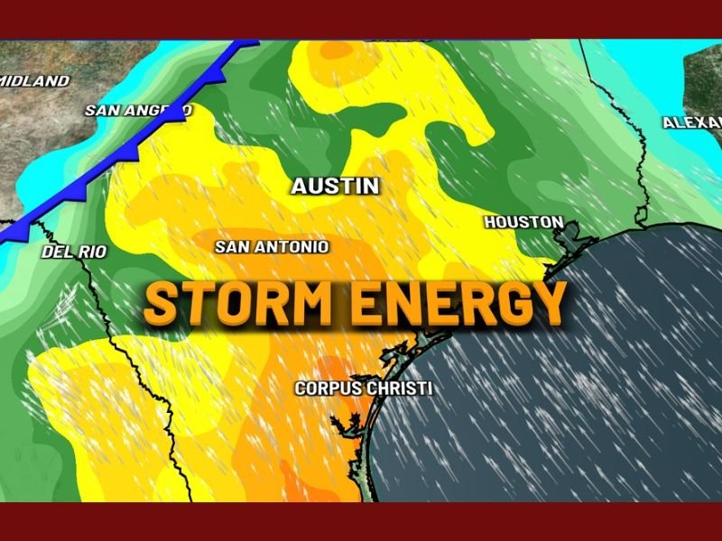
Forecast Models Indicate Strong Storm Energy Over Central Texas
According to computer model projections, atmospheric conditions are showing significant storm energy building over Central and South Texas, particularly around Austin, San Antonio, and Corpus Christi.
Maps shared by the First Warning Weather team display high levels of instability — highlighted in yellow and orange zones — that could fuel strong thunderstorm development. The greatest storm potential appears to be in regions stretching from Del Rio and San Angelo eastward through Austin and Houston, extending to coastal cities like Corpus Christi.
“Confidence is growing for a strong Pacific system to move in next Wednesday and Thursday,” forecasters said. “Model data continues to show plenty of storm energy, meaning severe weather can’t be ruled out.”
Cold Front Expected to Trigger Storms and Sharp Temperature Drop
As the Pacific system approaches, a cold front will push across the state, creating the lift and instability necessary for severe storm formation.
- Timing: The strongest storms are expected between Wednesday afternoon and early Thursday morning, with lingering rain possible into Friday.
- Main threats: Forecasters warn of damaging winds, hail, and heavy rainfall capable of producing localized flooding.
- Temperature changes: Following the storms, cooler air will move into Central and North Texas, dropping daytime highs by 15–25°F.
This transition marks one of the most dynamic weather shifts of the month for Texas, as the state moves from late-autumn warmth into early winter chill.
Cities at Risk for Severe Weather
Meteorologists note that Austin, San Antonio, and Houston are expected to see the brunt of Wednesday’s activity, with potential thunderstorms developing along the cold front line.
Further south, Corpus Christi and the Coastal Bend could experience strong wind gusts and heavy rain as the system intensifies near the Gulf. Western cities such as Midland and Del Rio may see earlier rain bands before the main front arrives.
Travel and Outdoor Impacts for Texans
The timing of this storm — just ahead of Thanksgiving week — may affect travel and outdoor events. Texans planning midweek activities should:
- Monitor weather alerts for flood watches and severe thunderstorm warnings.
- Avoid driving through flooded roadways or during active thunderstorms.
- Prepare for rapidly changing temperatures once the front passes through.
Forecasters expect gusty post-frontal winds late Thursday into Friday, particularly across open areas of Central and North Texas.
Looking Ahead: Cooler, Quieter Weekend After the Storm
After the front clears, Texas will see a notable cooldown, with morning lows dipping into the 40s and daytime highs struggling to reach the 60s in parts of the state.
Meteorologists say this marks the first of several cold fronts expected before Thanksgiving, part of a broader pattern shift toward winter-like conditions across the central United States.
“While this system looks strong, the models show even more active weather patterns lining up through late November,” the KXAN weather team noted.
Residents are encouraged to stay tuned for updates as meteorologists refine the forecast closer to midweek.
Do you think this mid-November storm marks the official start of winter weather in Texas? Share your thoughts and follow more regional weather updates at NapervilleLocal.com.

I’ve lived in Naperville long enough to see how quickly our community changes — from new developments downtown to sudden shifts in our Midwest weather. Reporting on Naperville news and daily forecasts gives me the chance to keep neighbors informed about what really matters. My goal is simple: deliver clear, timely updates so you always know what’s happening in our city and what to expect from the skies above.