
Strong Pacific Storm to Bring Heavy Rain, Mountain Snow, and Flood Risk to Southern California
LOS ANGELES — A powerful Pacific storm system is forecast to bring widespread rain, gusty winds, and significant mountain snowfall to Southern California this week, with impacts expected from Wednesday night through early Saturday, according to the latest forecasts.
Rain chances will sharply increase Wednesday night, with the heaviest precipitation expected Thursday into Friday, before tapering to lighter showers by the weekend.
Heavy Rain Expected Across the Region
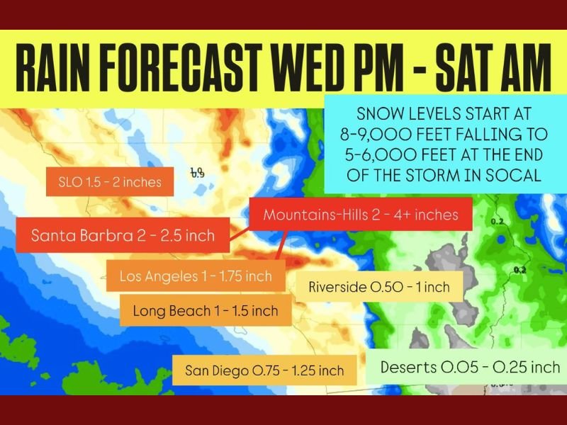
Meteorologists predict rainfall totals between 0.5 and 4 inches, depending on elevation and coastal proximity:
- Santa Barbara: 2 to 2.5 inches
- San Luis Obispo (SLO): 1.5 to 2 inches
- Los Angeles: 1 to 1.75 inches
- Long Beach: 1 to 1.5 inches
- San Diego: 0.75 to 1.25 inches
- Riverside: 0.5 to 1 inch
- Desert areas: 0.05 to 0.25 inches
- Mountain and hill zones: 2 to 4+ inches
Local officials warn that flooding and mudslides are possible, particularly near burn scars from recent wildfires where soil remains unstable.
“This will be a classic early-season Pacific storm,” a National Weather Service forecaster said. “Rainfall rates could exceed a half inch per hour at times, which means we could see urban flooding and slick roadways during peak commute hours.”
Snow Levels to Drop as Temperatures Fall
Snow levels are expected to begin near 8,000 to 9,000 feet, dropping to between 5,000 and 6,000 feet by the end of the storm. That could bring several inches of snow to mountain communities like Big Bear, Wrightwood, and the San Bernardino Mountains, making for difficult travel conditions on mountain passes.
Timeline for the Storm System
- Wednesday Night: Light rain develops along coastal and valley areas.
- Thursday: Heaviest rainfall expected across the region, possibly with isolated thunderstorms.
- Friday: Rain transitions to lighter, scattered showers.
- Saturday Morning: Drying trend begins, though snow lingers in higher elevations.
Meteorologists say this system could provide much-needed drought relief but caution that rapid runoff and flooding remain possible, especially in urban and low-lying areas.
Flooding and Mudslide Concerns
Communities in Santa Barbara, Ventura, and Los Angeles counties are at elevated risk of debris flows and small mudslides where wildfire burn scars exist. Emergency officials are urging residents to stay alert, avoid flooded roads, and monitor local weather alerts.
A Welcome But Risky Soaking
While the storm could ease dry conditions across parts of California, officials stress preparedness. The expected rainfall will reduce wildfire risk but could also trigger hazards in saturated zones.
“This storm is the kind we’ve been waiting for — beneficial overall, but with some serious local risks,” one meteorologist noted.
Stay updated on the latest California weather alerts and forecasts at NapervilleLocal.com.

I’ve lived in Naperville long enough to see how quickly our community changes — from new developments downtown to sudden shifts in our Midwest weather. Reporting on Naperville news and daily forecasts gives me the chance to keep neighbors informed about what really matters. My goal is simple: deliver clear, timely updates so you always know what’s happening in our city and what to expect from the skies above.