
Strong Thanksgiving Winds Sweep Across the Southeast, Bringing Chilly Air into Florida and Lower Temperatures for the Weekend
FLORIDA — Residents across the Southeast are feeling the arrival of strong Thanksgiving winds, as a surge of cool, dry air from the north pushes deep into the region. The cold front, which began sweeping southward early Thursday, is expected to bring gusts over 50 mph, significant temperature drops, and a sharp shift in humidity heading into Friday.
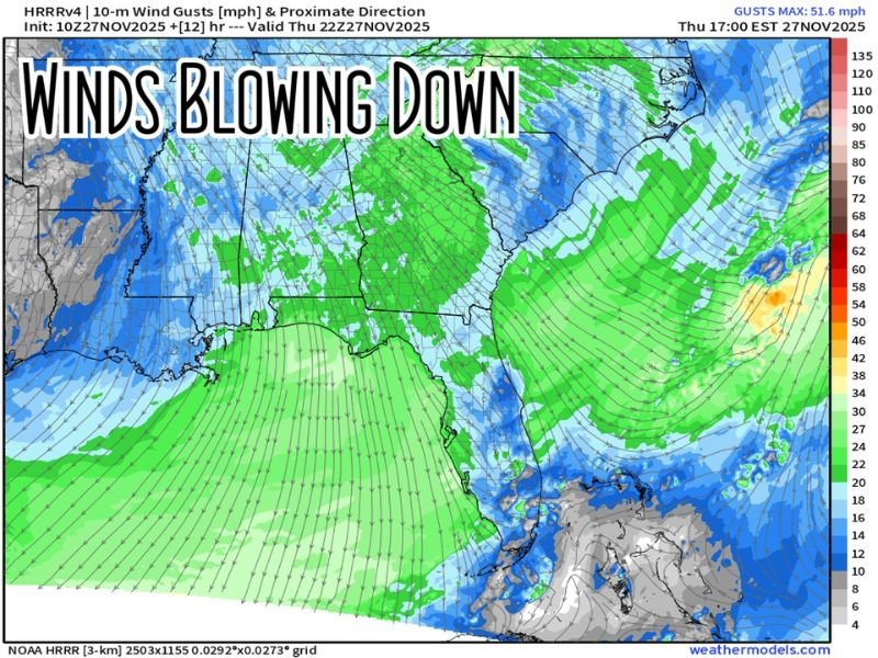
Forecast maps show widespread north-to-south wind patterns stretching from Tennessee and Georgia down into the Florida Panhandle, signaling a major weather transition after a mild start to the week.
Cold Air Arrives with Gusty Winds
According to high-resolution NOAA weather models, wind gusts between 30 and 50 mph are expected through Thursday evening, particularly across northern Florida, Alabama, and Georgia.
By late Thursday night, cooler air will continue spilling southward, pulling down temperatures into the 30s in northern areas and 50s farther south.
“This is a classic post-front setup — cold, dry air from the north racing into the Gulf states,” one meteorologist explained. “It’ll be a noticeable difference by Friday morning.”
Friday Brings Chilly Mornings and Cooler Highs
Morning lows are forecast to dip into the 30s in North Florida and South Georgia, while Central and South Florida will see 50s at sunrise. Afternoon highs on Friday will stay in the low 60s across much of the middle part of the state — a sharp contrast to earlier this week’s 70s.
The cooler pattern will persist into the weekend, with gradual warming returning by late Sunday.
Wind Impacts and Travel Considerations
The gusty winds may cause rough surf and hazardous boating conditions along the Gulf and Atlantic coasts through Thursday night. Travelers driving for the Thanksgiving holiday should be alert to crosswinds on highways and falling debris from weakened trees or power lines.
Forecasters urge residents to secure outdoor decorations and avoid open water until conditions calm down on Friday afternoon.
“It’s going to be one of those days where you’ll really feel the wind,” forecasters added. “Temperatures will fall fast after sunset — sweater weather is officially here.”
Weekend Outlook
- Friday Morning: 30s north, 50s south; windy and chilly
- Friday Afternoon: Mostly sunny, highs in the 60s
- Saturday–Sunday: Calmer winds, gradual warming to near 70°F
The pattern marks the first true cold-air push of the season for many parts of the Southeast, reminding residents that winter is around the corner.
For more regional forecasts, temperature maps, and weekend weather updates, visit NapervilleLocal.com for continuous coverage.

I’ve lived in Naperville long enough to see how quickly our community changes — from new developments downtown to sudden shifts in our Midwest weather. Reporting on Naperville news and daily forecasts gives me the chance to keep neighbors informed about what really matters. My goal is simple: deliver clear, timely updates so you always know what’s happening in our city and what to expect from the skies above.