
Strong Tornadoes and 60 to 80 MPH Wind Machine Targeting the Dakotas and Nebraska With Level 3 Enhanced Risk Running Well Into Tuesday Night
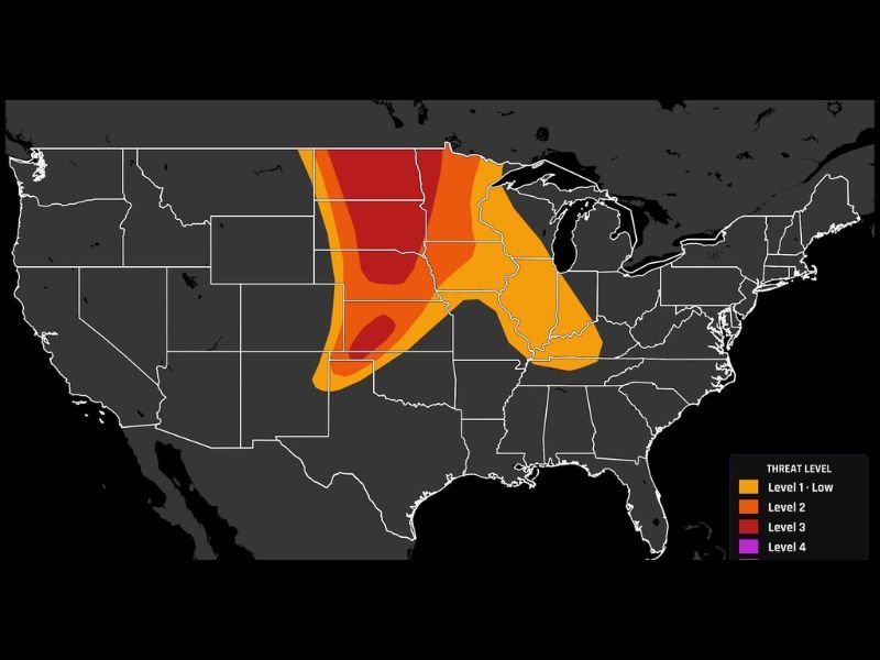
DAKOTAS AND NEBRASKA — The Dakotas and Nebraska are the primary severe weather target Tuesday June 9th as a trough rolling off the northern Rockies fires supercells along a dryline into a 70-degree dewpoint air mass by late afternoon. The SPC Day 1 outlook updated at 9:15 AM shows a Level 3 Enhanced Risk red zone centered over the Dakotas and Nebraska, surrounded by a Level 2 orange zone extending broadly through the central plains and upper Midwest.
This is a long-duration event running well into the overnight hours, making phone alerts critical through the entire night.
Supercells Fire Along the Dryline by Late Afternoon With Strong Tornado Potential
A trough moving off the northern Rockies will collide with a very moist 70-degree dewpoint air mass across the Dakotas and Nebraska, firing discrete supercells along the dryline by late afternoon. A few of these initial supercells could spin up strong tornadoes early in the event before the storm mode transitions.
The combination of extreme moisture, a well-defined dryline trigger, and strong wind shear creates a very favorable environment for organized and long-tracked supercell development during the late afternoon window.
Everything Transitions to a Wind Machine After Dark With 60 to 80 MPH Gusts
After the initial supercell phase, storms are expected to congeal into a powerful wind-producing squall line after dark, shifting the primary threat to destructive straight-line winds with gusts ranging from 60 to 80 mph. Wind gusts in this range cause widespread structural damage, down trees and power lines across large areas, and create extremely dangerous travel conditions throughout the overnight hours.
The after-dark transition makes this event especially dangerous as visual storm detection becomes impossible without radar.
Level 3 Risk Runs Well Into the Night Do Not Put the Phone on Silent
Forecasters are explicitly warning residents not to put phones on silent Tuesday night given that the Level 3 Enhanced Risk and associated severe weather threat runs well into the overnight hours. The broader Level 2 and Level 1 zones extend the threat from the central plains through the upper Midwest, putting communities from Omaha through Minneapolis and Chicago within at least a low-end severe weather footprint Tuesday evening and overnight. Stay with NapervilleLocal.com for the latest weather updates and local forecast coverage.

I’ve lived in Naperville long enough to see how quickly our community changes — from new developments downtown to sudden shifts in our Midwest weather. Reporting on Naperville news and daily forecasts gives me the chance to keep neighbors informed about what really matters. My goal is simple: deliver clear, timely updates so you always know what’s happening in our city and what to expect from the skies above.