
Strong Winds Forecast to Batter Texas, Alabama, Georgia, and the Carolinas Early Next Week, With Gusts Up to 50 MPH
ATLANTA, GEORGIA — Forecasters are warning residents across the Southern United States, particularly in Texas, Alabama, Georgia, and the Carolinas, to prepare for strong, damaging winds beginning Monday and continuing through Wednesday next week. Gusts are expected to reach 45–50 mph, posing risks for drivers, power lines, and unsecured outdoor items.
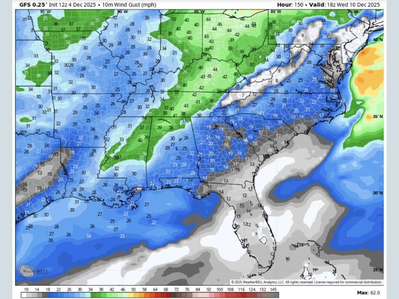
According to GFS weather models, the upcoming system will bring widespread gusty conditions as a powerful cold front sweeps eastward through the region. Meteorologists say the most intense winds will occur Tuesday through early Wednesday, with the potential for isolated power outages and travel delays.
Widespread Wind Gusts Expected Across the South
Data from WeatherBell Analytics shows that sustained winds of 30–40 mph will develop across Texas and Louisiana, while Mississippi, Alabama, and Georgia could experience gusts nearing 50 mph. In the Carolinas and Tennessee Valley, wind strength may vary but could still produce dangerous bursts in open areas and higher elevations.
Forecasters describe the pattern as part of a strong pre-winter jet stream moving through the South. As the system tightens pressure gradients, it’s expected to create conditions reminiscent of an early spring windstorm.
“These are not your regular breezy winds,” one forecaster said. “If it’s not tied down, it might just take off by Wednesday.”
Key Impact Zones
- Texas and Louisiana: Winds between 25–35 mph, strongest along highways and open plains.
- Mississippi and Alabama: Sustained gusts up to 45 mph, with potential for downed limbs and minor damage.
- Georgia and the Carolinas: Strongest gusts Tuesday evening through Wednesday, potentially topping 50 mph in exposed areas.
- Tennessee and Arkansas: Moderate but persistent winds around 30–40 mph, affecting truck routes along I-40.
Meteorologists note that while rainfall will be limited, the wind energy alone could make for hazardous driving, especially for high-profile vehicles.
Safety Precautions for Residents
Authorities urge residents to:
- Secure outdoor furniture, trash bins, and decorations.
- Avoid parking under large trees or power lines.
- Drive carefully on bridges and interstates, where crosswinds may be stronger.
Power companies across the affected states are monitoring conditions and preparing for potential outages if tree limbs or debris strike lines.
Winds to Ease After Midweek
The strongest gusts will gradually weaken by late Wednesday, but forecasters warn another round of unsettled weather could return later in December as jet stream patterns remain active.
“This system will mark one of the more significant wind events of early winter across the Southeast,” meteorologists noted. “People from Houston to Charlotte should prepare for at least one rough commute next week.”
For continued updates and safety guidance on developing weather systems, visit NapervilleLocal.com.

I’ve lived in Naperville long enough to see how quickly our community changes — from new developments downtown to sudden shifts in our Midwest weather. Reporting on Naperville news and daily forecasts gives me the chance to keep neighbors informed about what really matters. My goal is simple: deliver clear, timely updates so you always know what’s happening in our city and what to expect from the skies above.