
Strong Winds Up to 45 MPH Expected Across Oklahoma, Kansas, and Arkansas as Arctic Front Sweeps Through the Southern Plains
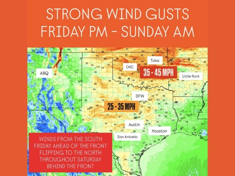
UNITED STATES — A powerful Arctic cold front will bring strong winds and rapidly falling temperatures to the Southern Plains beginning Friday afternoon, continuing through Sunday morning. Forecast data shows southerly wind gusts reaching 25 to 35 mph ahead of the front, with gusts intensifying to 40–45 mph once the front passes through regions of Oklahoma, southeastern Kansas, southwest Missouri, and northwest Arkansas.
Meteorologists are warning residents to secure outdoor decorations and holiday displays as strong, shifting winds are expected to impact several states through the weekend.
Wind Speeds Strengthen Ahead of the Arctic Front
Forecasters note that the first increase in wind speed will occur Friday afternoon across the Southern Plains, as warmer southerly air collides with the approaching Arctic cold mass. Gusts of 25–35 mph are possible across central and northern Texas, including areas near Dallas, Fort Worth, and San Antonio.
The winds will remain strong and steady overnight, extending northward into Oklahoma City, Tulsa, and Wichita, where the cold front is expected to arrive by early Saturday. These winds will create hazardous conditions for high-profile vehicles and east-to-west travel routes.
Winds Shift to the North and Intensify Behind the Front
By Saturday morning, the front will sweep across Oklahoma, Kansas, and Arkansas, shifting winds from the south to the north and increasing speeds behind the cold air boundary. Gusts as high as 45 mph are expected, particularly across eastern Oklahoma, southeastern Kansas, and the Ozark region.
Even the higher terrain of northern New Mexico will see strong gusts as the cold air mass descends into the region. Residents in these areas should brace for rapid temperature drops, blowing dust, and difficult driving conditions along open stretches of highway.
Sunday Morning Brings Gradual Wind Relief
The strong gusts will persist into Sunday morning before gradually easing as the Arctic front moves farther east. By Sunday afternoon, most of the Southern Plains will experience calmer, cooler air with northerly breezes between 15–20 mph.
Meteorologists caution that unsecured items such as Christmas decorations, patio furniture, and outdoor signage could be displaced by the powerful gusts. Motorists should also remain vigilant, especially when driving along open rural roadways where crosswinds can affect vehicle control.
Safety and Preparation Ahead of the Weekend
Officials recommend securing loose outdoor objects before the front’s arrival and avoiding unnecessary travel during peak wind periods. The combination of cold temperatures, dry air, and gusty winds could also increase fire danger in certain regions, even without widespread rainfall.
As the front continues to advance, conditions are expected to remain cold and breezy across much of the Southern Plains into early next week. Residents should monitor updated forecasts to stay informed on the latest timing and strength of the wind event.
Stay updated with NapervilleLocal.com for accurate national and regional weather coverage throughout the weekend.

I’ve lived in Naperville long enough to see how quickly our community changes — from new developments downtown to sudden shifts in our Midwest weather. Reporting on Naperville news and daily forecasts gives me the chance to keep neighbors informed about what really matters. My goal is simple: deliver clear, timely updates so you always know what’s happening in our city and what to expect from the skies above.