
Stronger Cold Front Targets Texas on March 1 as Mid-80s Warmup Fades and Winter Makes a Windy Comeback
TEXAS — Don’t let the surge into the mid-80s this week fool you. A stronger cold front is forecast to arrive Sunday, March 1, bringing gusty winds and a sharp drop in temperatures across much of Texas as winter pushes back.
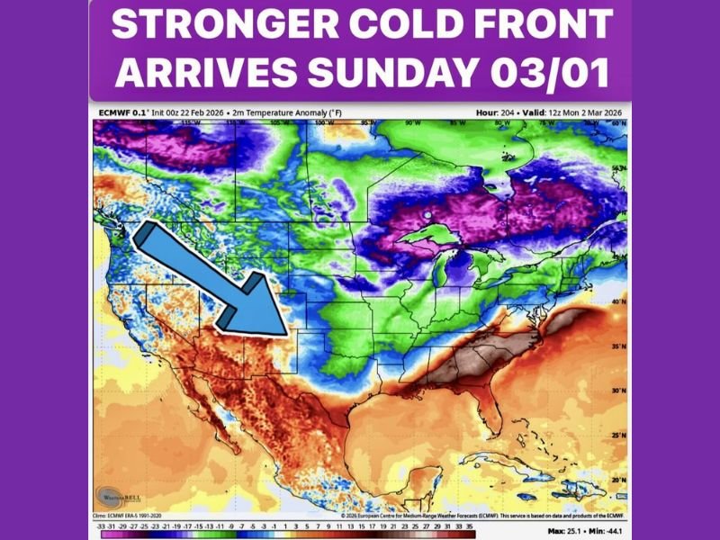
Forecast guidance shows a pronounced temperature swing developing late this week and into the weekend. While parts of Texas warm well above seasonal averages in the days ahead, colder air diving south from the Plains is expected to undercut that warmth quickly once the front moves through.
Warm Now, Cooler Fast
The upcoming warm spell may feel like early spring, but forecasters caution it’s too early to plant or assume the season has fully changed. The projected cold front is stronger than recent pushes and is expected to bring:
- Noticeably cooler daytime highs
- A brisk north wind behind the boundary
- A rapid temperature drop following frontal passage
Temperature anomaly maps indicate above-normal warmth ahead of the system, especially across central and southern Texas. Behind the front, cooler air spreads southward, signaling another round of late-season winter influence.
Windy Conditions With the Front
As the boundary moves through Sunday, windy conditions are likely, particularly across open areas of central and west Texas. While widespread rain is not expected with this system, the wind shift and falling temperatures will be noticeable.
Forecasters indicate no significant rainfall for the remainder of February, continuing the dry stretch across much of the state. However, precipitation chances may return during the first week of March as the broader weather pattern becomes more active.
Winter Pattern Not Done Yet
Despite the springlike warmth this week, long-range outlooks suggest winter still has multiple cold fronts left in the tank. The early-March setup hints at continued temperature swings rather than a steady warming trend.
The transition from late February into early March appears unsettled, with the potential for additional fronts to slide south into Texas before a more consistent spring pattern takes hold.
For now, residents can expect one more reminder that winter hasn’t fully let go.
What Texans Should Watch
- Sunday’s frontal timing and wind speeds
- Overnight lows early next week
- Early-March precipitation chances
Even after several warm afternoons, this stronger cold front underscores how quickly conditions can change across Texas during seasonal transitions. For continued weather coverage and detailed forecast updates, stay connected with NapervilleLocal.com.

I’ve lived in Naperville long enough to see how quickly our community changes — from new developments downtown to sudden shifts in our Midwest weather. Reporting on Naperville news and daily forecasts gives me the chance to keep neighbors informed about what really matters. My goal is simple: deliver clear, timely updates so you always know what’s happening in our city and what to expect from the skies above.