
Sunday: Arkansas Split in Two as Western Half Faces 80% Rain Chances and Eastern Half Battles Elevated Fire Danger With 80s Heat and Breezy Dry Conditions
LITTLE ROCK, Ark. — Arkansas is experiencing a dramatic weather divide this Sunday, with the western half of the state dealing with incoming showers and storm chances while the eastern half bakes under warm, dry, and breezy conditions that are raising elevated fire weather concerns. The contrast across the state is striking — Fayetteville and Fort Smith are sitting under an 80% chance of rain while Helena and Lake Village to the east have zero percent rain probability and temperatures climbing into the low-to-mid 80s.
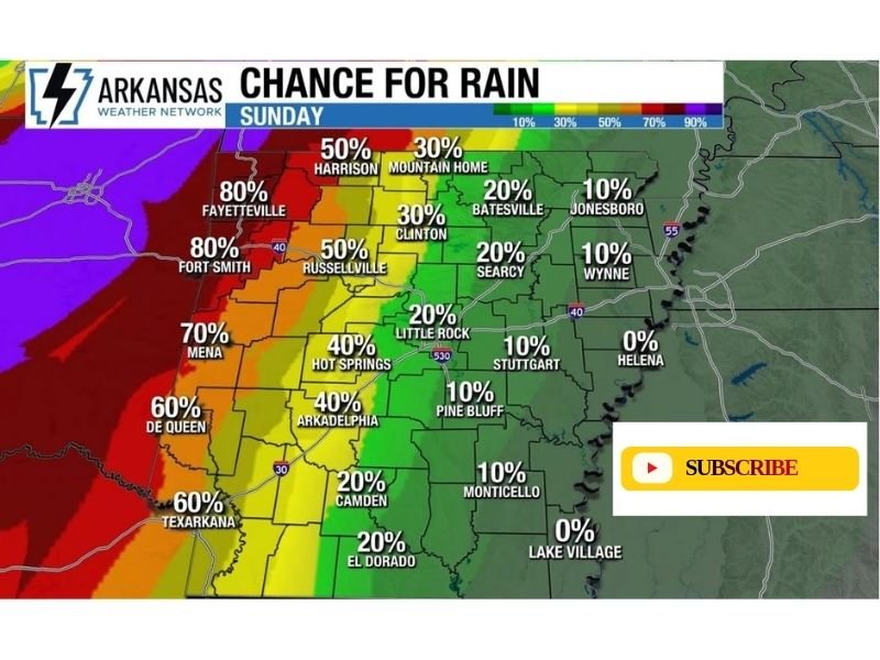
Western Arkansas Soaked With Up to 80% Rain Chances
Showers are already moving into western Arkansas this morning, bringing the highest rain probabilities in the state to communities along and west of the I-49 corridor. Fayetteville and Fort Smith lead the state with an 80% chance of rain today, followed closely by Mena at 70% and De Queen and Texarkana at 60%.
Moving slightly eastward, Harrison carries a 50% chance, Russellville sits at 50%, and Hot Springs and Arkadelphia are both at 40%. The rain is associated with an organized moisture push from the west, and while a few scattered storms are possible later today alongside the showers, the severe threat is considered extremely low across the entire western half of the state.
Central Arkansas Sees a Sharp Dropoff in Rain Chances
Through the central corridor of the state, rain probabilities drop off sharply. Little Rock sits at just 20%, with Searcy also at 20% and Clinton at 30%. Pine Bluff carries only a 10% chance, and Monticello sits at 10% as well.
This middle zone of the state represents the transition area between the wet west and the dry east, where clouds may linger but meaningful rainfall becomes increasingly unlikely through the afternoon hours.
Eastern Arkansas Dry and Fire Danger Elevated
Across the eastern half of Arkansas, the story is completely different. Jonesboro, Wynne, and Stuttgart are all sitting at just 10% rain chance, while Helena and Lake Village have a flat 0% probability of seeing any measurable rain today. These communities will remain completely dry throughout Sunday.
In place of rain, eastern Arkansas is dealing with temperatures climbing into the low-to-mid 80s, breezy winds, and dry atmospheric conditions — a combination that is raising elevated fire danger across the region. Residents in eastern Arkansas should avoid any outdoor burning today and remain cautious with any activity that could spark a fire in dry vegetation.
High Temperatures Show the East-West Divide Clearly
The high temperature map reinforces the stark split across the state. Eastern Arkansas communities are running the warmest, with Lake Village, El Dorado, Camden, Monticello, and Texarkana all reaching 84°F. Jonesboro, Wynne, Helena, and Stuttgart are hitting 82–84°F under mostly sunny skies.
Meanwhile, western Arkansas is running noticeably cooler thanks to cloud cover and rain. Fayetteville tops out at just 74°F, Mena at 74°F, and Fort Smith at 77°F — a difference of nearly 10 degrees compared to the dry and sunny eastern communities.
Showers and Storms Spread East Tonight With Light Amounts
As the day progresses into Sunday night, the rain chance picture shifts considerably eastward. The Sunday night rain probability map shows a much broader area of the state coming under shower and storm chances overnight, with Fort Smith rising to 60%, Fayetteville and Texarkana at 60%, and communities across central Arkansas including Little Rock, Hot Springs, and Russellville climbing to 40–50%.
Even eastern communities that stay dry through the day will see increasing rain chances overnight, with Jonesboro, Wynne, and Batesville all moving into the 40–50% range by Sunday night. Any rainfall amounts are expected to remain on the light side as the moisture spreads eastward across the state.
Stay with NapervilleLocal.com for the latest weather updates and local forecast coverage.

I’ve lived in Naperville long enough to see how quickly our community changes — from new developments downtown to sudden shifts in our Midwest weather. Reporting on Naperville news and daily forecasts gives me the chance to keep neighbors informed about what really matters. My goal is simple: deliver clear, timely updates so you always know what’s happening in our city and what to expect from the skies above.