
Sunday: Critical Fire Weather Alert Issued Across Most of Kentucky as Low Humidity, Dry Grounds, and Winds Create Dangerous Fire Spread Conditions
FRANKFORT, Ky. — The National Weather Service Storm Prediction Center has issued a significant fire weather outlook for Sunday, April 12, 2026, covering a large swath of Kentucky from the western end of the state all the way through the central and northern regions. A dangerous combination of low humidity, mostly dry ground conditions, and active winds is creating elevated fire spread probabilities that forecasters and officials are treating with serious urgency.
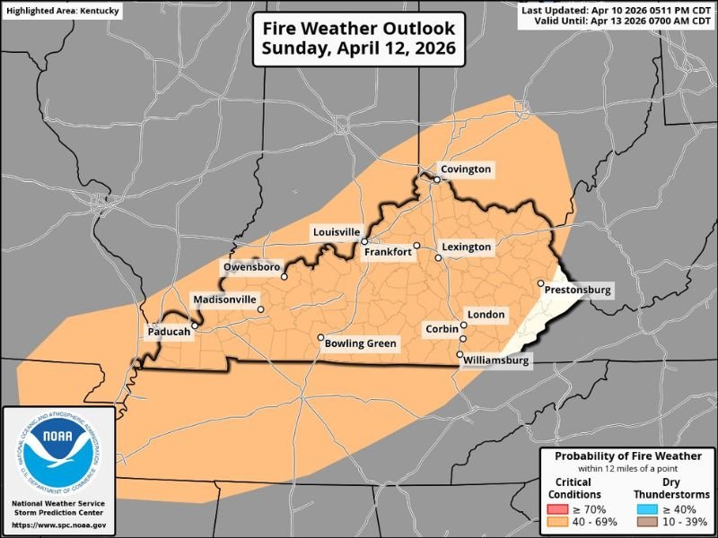
Fire Weather Outlook Covers Majority of the State
The NOAA Storm Prediction Center’s fire weather outlook, valid through April 13, 2026 at 7:00 AM CDT, places most of Kentucky under an elevated fire weather threat for Sunday. The affected zone stretches across a broad diagonal swath running from the far western tip of the state near Paducah through central Kentucky — including Louisville, Frankfort, Lexington, and Covington — and extending into portions of the eastern region near Prestonsburg.
Areas including Owensboro, Madisonville, Bowling Green, Corbin, London, and Williamsburg all fall within the outlined risk zone as well, meaning the threat is not confined to any single part of the state.
Probability of Critical Fire Conditions at 40 to 69 Percent
According to the NOAA outlook map, the probability of fire weather conditions within 12 miles of a point across the highlighted zone falls in the 40 to 69 percent range, classified under critical conditions. This level of probability is considered significant enough to warrant a formal alert and a direct public warning to avoid all outdoor burning on Sunday.
The combination of three key factors is driving the elevated risk — low relative humidity pulling moisture out of vegetation and soil, mostly dry ground conditions following a stretch of limited rainfall, and winds capable of rapidly spreading any fire that ignites.
Officials Issue Clear Warning: Do Not Burn on Sunday
The message from forecasters is direct and urgent — do not burn anything outdoors in Kentucky on Sunday. Any open flame, whether from debris burning, campfires, or agricultural burning, carries a significantly heightened risk of escaping and spreading rapidly under these conditions.
Dry vegetation acts as ready fuel, and with winds in the forecast, even a small and seemingly controlled fire can move quickly and dangerously. Residents across all affected areas are strongly urged to postpone any planned burning until conditions improve and humidity levels recover.
Western Kentucky Faces the Broadest Exposure
While the threat covers a large portion of the state, the western end of Kentucky — including Paducah, Madisonville, and the surrounding communities — sits within the widest part of the outlined risk area. These locations may experience the most persistent combination of dry and windy conditions throughout the day on Sunday.
Northern Kentucky communities near Covington and the Greater Louisville metro area are also included in the zone, reminding residents that this is not solely a rural concern — suburban and urban-fringe areas with dry grass and open land are equally vulnerable. Stay with NapervilleLocal.com for the latest weather updates and local forecast coverage.

I’ve lived in Naperville long enough to see how quickly our community changes — from new developments downtown to sudden shifts in our Midwest weather. Reporting on Naperville news and daily forecasts gives me the chance to keep neighbors informed about what really matters. My goal is simple: deliver clear, timely updates so you always know what’s happening in our city and what to expect from the skies above.