
Sunday: Warm, Windy, and Dry Across Colorado With Widespread 70s, Isolated Showers West of the Continental Divide, and an Active Storm Pattern Building Into Next Week
DENVER, Colo. — Colorado is kicking off Sunday with a warm, dry, and increasingly windy day as a building southwest flow ramps up ahead of the next incoming weather system. Widespread temperatures in the 70s will dominate the eastern plains and Front Range today, with a few low 80s possible east of the Continental Divide.
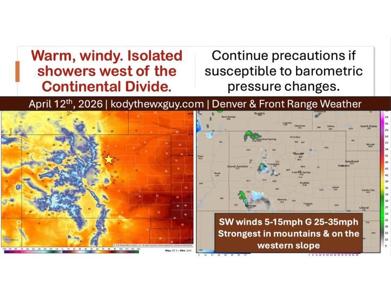
Meanwhile, isolated showers are possible west of the Divide, and residents sensitive to barometric pressure changes are advised to continue taking precautions as the pattern remains active heading into the week ahead.
Widespread 70s Dominate the Eastern Plains and Front Range
Temperatures across the eastern half of Colorado are running warm today, with the plains east of the Continental Divide seeing the best and warmest readings. The eastern plains are pushing into the low 80s in several locations, while the Denver and Front Range corridor sits comfortably in the mid-to-upper 70s.
West of the Divide, temperatures are noticeably cooler, with readings dropping into the low 70s across the western slope. The San Luis Valley and higher mountain elevations are running even cooler, as elevation continues to play its predictable role in keeping those communities several degrees behind their lower-altitude neighbors.
Southwest Winds 5–15 MPH Gusting 25–35 MPH — Strongest in the Mountains
Wind will be one of the defining features of Sunday across Colorado. Southwest winds of 5 to 15 mph are expected across most of the state, but gusts will be significantly stronger — reaching 25 to 35 mph at times, particularly across the mountain ranges and along the western slope where terrain funnels and amplifies the flow.
Residents in the foothills and mountain communities should be prepared for periods of strong and gusty winds throughout the day. The breezy conditions will also combine with the dry airmass to maintain elevated fire weather awareness across portions of the state.
Isolated Showers Possible West of the Continental Divide
While most of Colorado stays dry today, a few isolated showers could squeeze out west of the Continental Divide through Sunday and again into Monday. Activity near Steamboat Springs, Durango, and the broader western slope is most likely, as moisture interacts with the higher terrain in those areas.
These showers will be light and isolated in nature — not a significant rain event by any measure — but enough to briefly dampen conditions in a few western communities. The eastern plains and Front Range are expected to remain completely dry through the day.
Tuesday System Brings Scattered Hit-or-Miss Showers
The next notable weather maker arrives Tuesday in the form of a weak but compact storm system moving across Colorado. This system will eject into the central plains late Tuesday into Wednesday, bringing scattered and hit-or-miss shower activity along with it.
Timing and exact impacts are still being refined, and forecasters will fine-tune the details as the system draws closer. The setup is not expected to be a major event, but it will introduce precipitation chances back into the forecast for a broader portion of the state midweek.
Another Front Arrives Late Thursday Into Friday
Following the Tuesday system, another frontal boundary is set to roll through Colorado late Thursday into Friday, bringing cooler temperatures, increased wind, and another round of precipitation chances to close out the week.
Longer-range weather models continue to signal an active overall pattern for the region, with multiple systems in the pipeline over the coming days. Residents should stay tuned for updated forecasts as each system approaches and details come into sharper focus. Stay with NapervilleLocal.com for the latest weather updates and local forecast coverage.

I’ve lived in Naperville long enough to see how quickly our community changes — from new developments downtown to sudden shifts in our Midwest weather. Reporting on Naperville news and daily forecasts gives me the chance to keep neighbors informed about what really matters. My goal is simple: deliver clear, timely updates so you always know what’s happening in our city and what to expect from the skies above.