
Supercell Storm Pattern Could Ramp Up Across Texas, Oklahoma and the Mid-South as February Turns “Active”
TEXAS — A new late-February outlook is pointing to a more active U.S. weather pattern as warmer air starts pushing into lingering cold, creating a setup that can deliver multiple storm systems over the next couple of weeks. The same pattern can produce snow or ice on the cold side, but it can also open the door to severe thunderstorms and potential supercells on the warm side—especially as the calendar pushes deeper into the second half of February and toward early March.
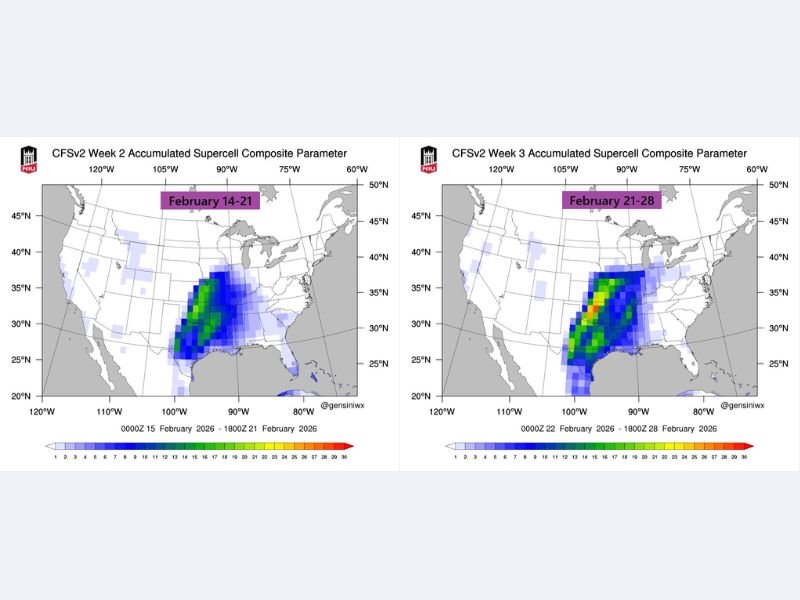
What the new maps are signaling for Feb. 14–21 and Feb. 21–28
The forecast graphics highlight a corridor where supercell-friendly conditions may be more likely during two windows:
- Feb. 14–21: The signal focuses on a broad zone running from parts of Texas northward into the Central Plains, with the strongest clustering appearing in the southern/central Plains into the lower Mid-South region.
- Feb. 21–28: The corridor looks more pronounced and slightly shifted, again favoring areas from Texas and Oklahoma into parts of Arkansas and nearby Mid-South states, suggesting the severe-weather setup could repeat or persist.
These are not day-by-day storm forecasts. They’re a “pattern” signal—basically a heads-up that the background environment could become more favorable for severe storms if individual storm systems track the right way.
Why warmer air battling cold air matters
When a warming trend begins to “attack” cold air that’s still in place, it can sharpen the temperature contrast over the middle of the country. That clash is often what fuels:
- Strong storm systems moving out of the Plains
- Severe thunderstorms on the warm, humid side
- Wintry precipitation (snow/ice) on the colder side of the same system
So even if the highest supercell risk stays south and west of Illinois, the overall pattern can still mean more frequent swings in temperature, wind, and precipitation potential across the Midwest.
What this could mean for Naperville and the Chicago suburbs
For northeastern Illinois, the most important takeaway isn’t that supercells are guaranteed locally—it’s that an active storm track can bring quick changes:
- A warmer surge can push temps up sharply, then drop them fast once a front passes.
- If a storm track runs close to the region, a narrow shift north or south can be the difference between cold rain, wet snow, or an ice mix.
- Even when severe storms stay south, Illinois can still see strong gradient winds, heavy rain, or a burst of convective showers along the front.
If the pattern holds into early March as suggested, it’s the kind of setup where residents should be ready for multiple “systems” instead of one clean forecast for the entire week.
Where the higher severe-weather focus appears right now
Based on the highlighted corridor in the maps, the strongest supercell signal is centered most consistently across parts of:
Texas, Oklahoma, Arkansas, Louisiana, Mississippi, and potentially into nearby Mid-South zones (including parts of Tennessee/Missouri depending on track).
The placement matters because a small shift in storm track can pull that risk north or keep it pinned farther south. That’s why updates closer to each system will be more reliable than any single long-range map.
What to watch as we get closer
As February progresses, the key details that will determine impacts in Illinois include:
- Storm track: A more northern track can bring heavier rain and stronger storms farther north; a southern track can keep Illinois colder with more wintry risk.
- Timing: The difference between a night-time front and daytime heating can affect storm intensity well south of Illinois—and can change how strong winds and rain become locally.
- Temperature profile: Even a 2–3 degree change near freezing can flip precipitation type quickly.
The bottom line
The late-February setup being advertised is a classic “busy pattern” signal: more systems, bigger swings, and higher odds for impactful weather somewhere in the central U.S. The clearest severe signal is currently focused from Texas into the Mid-South, but the Midwest—including Illinois—can still feel the ripple effects through wind, sharp temperature drops, and wintry/rainy transitions depending on how each storm tracks.
Want more updates like this written for regular people—not meteorology jargon? Share what you’re seeing in your neighborhood, and keep checking back with NapervilleLocal.com for the next round of timing and impacts as the pattern comes into sharper focus.

I’ve lived in Naperville long enough to see how quickly our community changes — from new developments downtown to sudden shifts in our Midwest weather. Reporting on Naperville news and daily forecasts gives me the chance to keep neighbors informed about what really matters. My goal is simple: deliver clear, timely updates so you always know what’s happening in our city and what to expect from the skies above.