
Tampa Bay Area Sees Rare Overnight Snow Flurry Window as Arctic Air Pushes Into West-Central Florida
FLORIDA — A rare winter weather setup could bring snow flurries to parts of the Tampa Bay area late Saturday night into early Sunday morning, according to forecast guidance issued by the National Weather Service office in Tampa Bay/Ruskin.
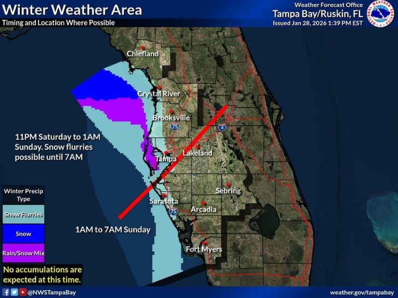
The forecast highlights a narrow coastal zone along west-central Florida where Arctic air moving over the eastern Gulf may briefly support snow flurries or a rain-snow mix. While this is an unusual scenario for Florida, officials stress that no accumulation is expected, and impacts should remain minimal.
When Snow Flurries Could Occur
The timing window for any wintry precipitation is short. Forecast data shows the best chance for snow flurries between 11 PM Saturday and 1 AM Sunday, with flurries potentially lingering in some locations until around 7 AM Sunday.
This timing coincides with the coldest overnight temperatures, which are necessary for flakes to survive to the surface in Florida’s typically warm environment.
Where the Best Chances Exist
The highest potential is focused along the immediate Gulf Coast of west-central Florida, including areas near Crystal River, Brooksville, Tampa, Sarasota, and southward toward Fort Myers. Offshore and near-coastal zones show the strongest signal for snow flurries, while inland areas are more likely to see cold rain or no precipitation at all.
A narrow band of rain-snow mix is also possible near the coast, but the setup remains highly localized.
What This Means for Travel and Impacts
Despite the unusual nature of the forecast, no snow accumulation is expected at this time. Roads are not expected to become snow-covered, and significant travel disruptions are unlikely.
However, brief reductions in visibility could occur if flurries develop, especially near the coast and during the early-morning hours. Residents are advised to remain aware of changing conditions, particularly if traveling late at night.
Why This Is a Rare Florida Setup
Snow flurries in Florida require a precise balance of Arctic cold air, moisture, and timing. In this case, extremely cold air aloft combined with Gulf moisture creates just enough instability for flurries, even though surface temperatures remain marginal.
Events like this are uncommon and often short-lived, which is why forecasters continue to emphasize managing expectations.
The Bigger Story Remains the Cold
While snow flurries are drawing attention, extreme cold remains the primary weather concern across Florida. Residents should continue cold-weather precautions, including protecting pets, plants, and exposed pipes. Any snow that does fall would be brief, light, and mainly a novelty rather than a disruptive event.
For continued coverage of unusual winter weather patterns across the country and why they matter, stay with NapervilleLocal.com for the latest updates.

I’ve lived in Naperville long enough to see how quickly our community changes — from new developments downtown to sudden shifts in our Midwest weather. Reporting on Naperville news and daily forecasts gives me the chance to keep neighbors informed about what really matters. My goal is simple: deliver clear, timely updates so you always know what’s happening in our city and what to expect from the skies above.