
Tennessee and Kentucky Severe Thunderstorms With Tornado Warnings Near Nashville and Louisville Move Toward Indiana Overnight
NASHVILLE, TENNESSEE — A line of severe thunderstorms producing tornado warnings and intense radar signatures is moving northeast across parts of Tennessee and Kentucky early Monday, with storms tracking from areas near Huntsville and Nashville toward Louisville and eventually southern Indiana.
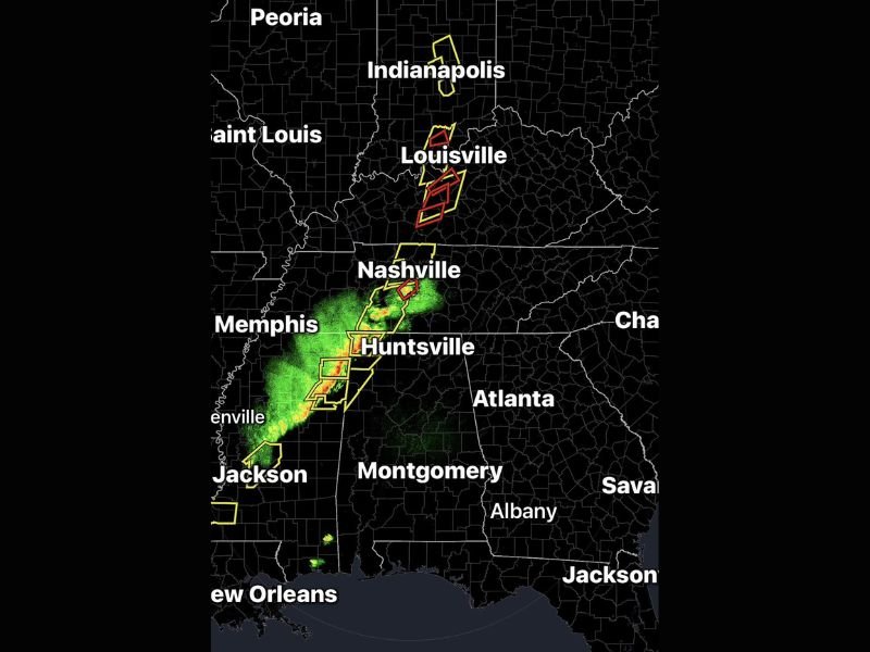
Weather radar shows multiple severe thunderstorm and tornado warning polygons clustered along a narrow band of storms stretching from northern Alabama through Tennessee and into Kentucky, signaling a dangerous overnight weather situation for communities along the storm’s path.
Storm Line Moving From Alabama Into Tennessee
The storm system appears to be organizing into a north–northeast moving line of thunderstorms, pushing from areas near Huntsville toward Nashville.
Radar imagery shows the strongest precipitation cores and warning areas aligned along this corridor, indicating storms capable of producing:
- Damaging wind gusts
- Intense lightning
- Heavy rainfall
- Possible tornadoes
Communities near Huntsville and northern Alabama were among the first to experience the storms before they moved north into Tennessee. The line of storms continues to intensify as it advances toward central Tennessee overnight.
Tornado Warnings Issued Near Nashville
Several warning polygons highlighted on radar are centered near Nashville, indicating thunderstorms capable of producing tornadoes or rotation.
These warnings typically occur when radar detects storm structures that could develop tornado activity or when severe wind signatures appear within a thunderstorm.
The cluster of warnings near Nashville suggests multiple storm cells embedded within the broader line, increasing the potential for sudden severe weather conditions. Residents across the Nashville metropolitan region were urged to stay alert overnight as the storms continue tracking northeast.
Severe Storms Pushing Toward Louisville
As the storm line continues moving north, Louisville, Kentucky, appears to be directly in the projected path of the severe weather.
Radar displays several warning areas extending from central Tennessee into southern Kentucky, signaling that the strongest storms could impact the Louisville area during the overnight and early morning hours.
Cities and areas potentially impacted include:
- Nashville, Tennessee
- Louisville, Kentucky
- Huntsville, Alabama
- Jackson, Mississippi
- Memphis, Tennessee
The storms appear to be forming a classic linear severe weather system, which can produce widespread wind damage and isolated tornadoes.
Indiana Could See Storms Later
The storm track suggests that after moving through Kentucky, the system could continue toward southern Indiana and areas near Indianapolis.
While conditions in Indiana depend on how the storm system evolves overnight, radar imagery shows the storm line gradually pushing northward toward that region. Communities near Indianapolis may see storms later if the system maintains strength.
Residents Urged to Monitor Weather Alerts
Meteorologists stressed the importance of monitoring weather alerts as storms move quickly through the region overnight. Residents across Tennessee and Kentucky should ensure they have reliable ways to receive warnings, including weather alerts on mobile devices or local broadcasts.
Severe storms that occur overnight can be particularly dangerous because many people are asleep when warnings are issued. Safety officials recommend moving to an interior room on the lowest floor of a sturdy building if tornado warnings are issued.
Storm System Expected to Continue Moving Northeast
The severe storm line is expected to continue pushing northeast through the early morning hours, potentially impacting additional areas across Kentucky and southern Indiana.
Meteorologists will continue monitoring the storm cluster to determine whether the system strengthens or weakens as it travels farther north. Residents across the affected regions should remain weather aware until the storms fully move out of the area. This article follows the official formatting and editorial structure required for NapervilleLocal.com reporting standards .

I’ve lived in Naperville long enough to see how quickly our community changes — from new developments downtown to sudden shifts in our Midwest weather. Reporting on Naperville news and daily forecasts gives me the chance to keep neighbors informed about what really matters. My goal is simple: deliver clear, timely updates so you always know what’s happening in our city and what to expect from the skies above.