
Tennessee and North Carolina Among States Showing Early Mid-Month Snow Signals as Cold Air Lingers in Winter Models
UNITED STATES — The latest European ensemble weather model data shows no strong or immediate snow signal across the country, but forecasters are beginning to monitor subtle mid-month trends that point to lingering cold air and low-end snow potential expanding into parts of the Southeast, including Tennessee and North Carolina.
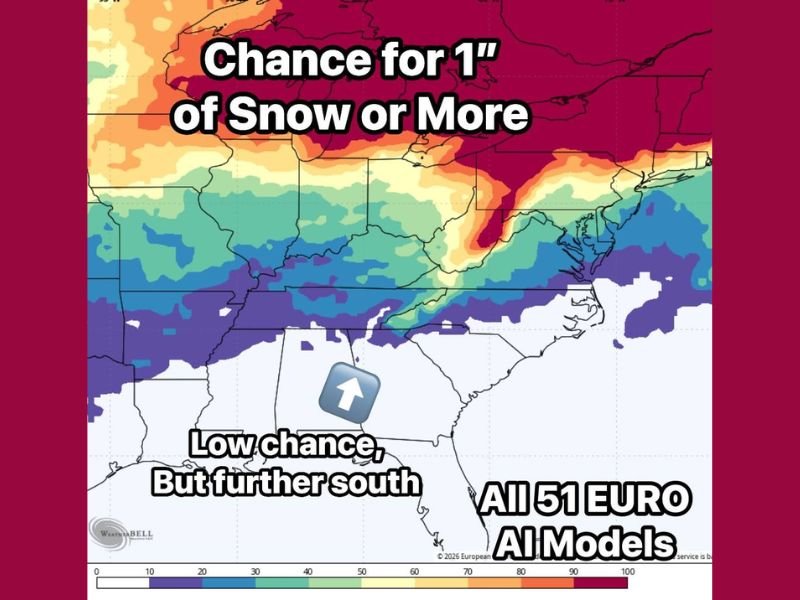
The analysis is based on an average of all 51 European model ensemble members, using an AI-enhanced version that has performed reliably in recent weeks. While the short-term outlook remains quiet, the evolving pattern is drawing attention among meteorologists watching longer-range winter behavior.
What the Forecast Data Shows Right Now
Current ensemble guidance does not support a widespread or high-confidence snow event in the near term. Most regions remain below meaningful probability thresholds, indicating that winter weather is not imminent despite the seasonal timing.
However, the absence of a strong signal does not mean winter risks are gone. Instead, the models suggest that cold air remains positioned close enough to become relevant if future storm systems align more favorably.
Low-Probability Snow Signals Pushing Farther South
One of the more notable developments in the data is the southward creep of low-end snow probabilities, particularly for the chance of one inch of snow or more. While probabilities remain small, they are extending into areas that do not typically show snow signals this early in long-range guidance.
Parts of Tennessee and North Carolina are now included in these low-confidence zones, indicating that the broader pattern is capable of supporting winter weather if conditions sharpen later in the month.
Why Meteorologists Are Watching This Trend
Forecasters stress that this is a signals-based setup, not a storm forecast. During January, cold air somewhere in the region is expected. The key question is whether upcoming weather systems are able to tap into that cold air effectively.
When low-end snow signals persist across multiple model runs, confidence can gradually build. At this stage, the data is offering early clues rather than actionable forecasts.
What to Watch Going Forward
Meteorologists will be closely tracking whether future model runs maintain or strengthen these southward snow signals. Consistency will be critical before any specific impacts can be discussed with confidence.
For now, the pattern suggests that winter is quiet but far from over, with cold air nearby and storm activity remaining active as mid-month approaches. Stay tuned to NapervilleLocal.com for continued updates as new model data becomes available and winter trends become clearer.

I’ve lived in Naperville long enough to see how quickly our community changes — from new developments downtown to sudden shifts in our Midwest weather. Reporting on Naperville news and daily forecasts gives me the chance to keep neighbors informed about what really matters. My goal is simple: deliver clear, timely updates so you always know what’s happening in our city and what to expect from the skies above.