
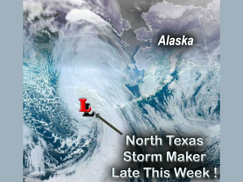
Texas and Alaska Weather Pattern Shows Why North Texas Could See Widespread Rain and Thunderstorms Late Friday Into Saturday After Another Week of 70s and 80s
TEXAS — North Texas is heading into another unseasonably warm stretch with highs in the 70s and even a few 80s, but forecasters are also watching a stronger storm system now moving through the western Aleutian Islands of Alaska that could drive a more widespread round of rain and thunderstorms late Friday into Saturday morning.
Warm Start to the Week, With Only a Small Rain Chance Tuesday
The early-week forecast stays mostly quiet despite the mild air. A modest upper-level disturbance may bring a spotty shower chance late Tuesday, but rain coverage looks limited and amounts appear light, with the better chance arriving Tuesday night.
Even with a few brief sprinkles, the bigger story through midweek is the warmth, running well above typical February levels for many locations across North Texas.
The Main System to Watch: Late Friday Night Into Saturday
A stronger disturbance is expected to arrive Friday night, bringing an increased chance for more widespread rain and embedded thunderstorms across parts of North Texas. The timeframe highlighted in the forecast discussion centers on the overnight hours into early Saturday, when gusty winds and lightning may accompany the heavier pockets of rain.
The current thinking is that storms should remain non-severe, especially if the best lift and instability arrive during the overnight window. Still, any thunderstorm can produce brief downpours, sudden wind gusts, and dangerous cloud-to-ground lightning.
Valentine’s Weekend Timing Still Being Fine-Tuned
As the system moves through, Saturday could stay wet into at least part of the day, with a cool front helping to push the rain east. Forecast timing may shift as confidence improves, since the setup is still several days out and the exact track will control where the steadiest rain sets up.
No Winter Weather Showing Up in This Setup
While some social media posts may hint at Arctic air or a sudden flip to snow/ice, the current outlook described in the forecast materials shows no sign of winter weather for North Texas with this pattern. The late-week system looks like a rain-and-thunder type event rather than a wintry one.
Why Forecasts Can Look Wild Far Out
The discussion also highlights a key point: long-range “headline” forecasts can change quickly when they’re based on a single model run. Meteorologists compare many model solutions and look for trends across multiple runs to avoid overreacting to one dramatic scenario.
What to Watch Next
As the late-week system gets closer, the most important updates will be:
- Exact timing of the heaviest rain (late Friday night vs. more into Saturday)
- Thunderstorm coverage and whether storms remain mainly overnight
- Wind potential behind the front as the system exits
If you’re following weather closely this week, expect refinements to the track and timing as newer data comes in.
If you found this forecast breakdown helpful, follow along with NapervilleLocal.com for more weather updates and explainers like this—what are you seeing in your area, and do you think this late-week storm trend is starting to look more likely?

I’ve lived in Naperville long enough to see how quickly our community changes — from new developments downtown to sudden shifts in our Midwest weather. Reporting on Naperville news and daily forecasts gives me the chance to keep neighbors informed about what really matters. My goal is simple: deliver clear, timely updates so you always know what’s happening in our city and what to expect from the skies above.