
Texas and Louisiana Under Tornado Watch as Severe Nighttime Storms Threaten High Winds and Hail
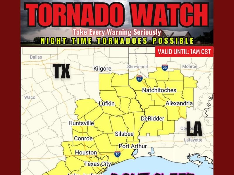
HOUSTON, TEXAS — A Tornado Watch has been issued for northern and central Louisiana, east-central and southeast Texas, and surrounding coastal waters as severe thunderstorms sweep through the Gulf Coast region late Monday night.
According to the National Weather Service, the Tornado Watch remains active from 6:35 p.m. to 1:00 a.m. CST, with forecasters warning of multiple hazards, including:
- A couple of tornadoes possible
- Damaging wind gusts reaching up to 70 mph
- Large hail up to 1.5 inches in diameter
Dangerous Overnight Storms Expected
Meteorologists are emphasizing the heightened risk of nighttime tornadoes, which are particularly dangerous due to reduced visibility and sleeping residents often missing alerts.
The storm system currently spans from Houston, Conroe, and Lufkin in Texas to Alexandria, Natchitoches, and DeRidder in Louisiana.
Weather radar images show large sections of southeast Texas, including Port Arthur, Lake Jackson, and Texas City, under active monitoring.
Officials Urge Residents to Remain Alert
“Stay weather aware tonight. Make sure your devices are charged, alerts are on, and you have a way to receive warnings,” forecasters advised.
Emergency services urge residents to avoid travel, keep interior shelter areas ready, and stay away from windows during the storm’s peak.
The National Weather Service added that storm cells capable of rotation have already been detected near parts of the Houston metro area, with conditions favorable for rapid tornado development.
Outlook Through the Night
Forecasters predict that the storm line will continue eastward overnight, bringing heavy rainfall and gusty winds before weakening early Tuesday morning.
Travelers along the I-10 and I-49 corridors are advised to use caution due to slick roads and limited visibility.
Stay with NapervilleLocal.com for continuous weather updates and national severe storm coverage.

I’ve lived in Naperville long enough to see how quickly our community changes — from new developments downtown to sudden shifts in our Midwest weather. Reporting on Naperville news and daily forecasts gives me the chance to keep neighbors informed about what really matters. My goal is simple: deliver clear, timely updates so you always know what’s happening in our city and what to expect from the skies above.