
Texas and Oklahoma Brace for Winter Mix as Strong Cold Front Brings Snow, Sleet, and Rapid Temperature Drops
Texas and Oklahoma are preparing for a burst of winter weather late Sunday as a strong cold front sweeps across the region, bringing a mix of light snow, sleet, and scattered rain showers from the Texas Panhandle to central Oklahoma. Forecast visuals highlight expanding zones of light snow near Amarillo, sleet risks from Wichita into Tulsa and Oklahoma City, and light showers in North Texas, all developing as temperatures fall sharply behind the advancing front.
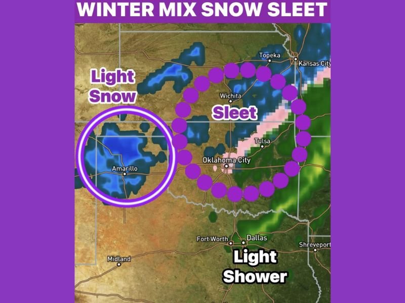
Winter Weather Zones Identified in Forecast Maps
Meteorologists are tracking three distinct precipitation zones across Texas and Oklahoma. The Texas Panhandle, particularly around Amarillo, is in the highest probability zone for light snow, as colder air arrives rapidly behind the front. Snowfall amounts are expected to remain light but may cause reduced visibility and slick spots, especially overnight.
Farther northeast, a broad zone stretching from Wichita into Tulsa and Oklahoma City is highlighted for sleet and mixed precipitation. This corridor is expected to see temperatures fall quickly enough to transition rain into frozen precipitation, creating the potential for hazardous travel conditions even with limited accumulation.
In North Texas, including areas near Dallas and Fort Worth, the system is expected to produce light showers with temperatures dropping sharply afterward. While not all areas will see snow or sleet, the abrupt cooldown may still affect early morning travel and outdoor plans.
Timing and Expected Impacts
The strong cold front is predicted to arrive Sunday night, moving swiftly across the region. Its fast motion will limit total precipitation but will significantly impact temperature readings, dropping them rapidly in just a few hours.
This sudden temperature change increases the likelihood that rain transitions into sleet or snow, particularly in Oklahoma and the Texas Panhandle. Even light amounts of frozen precipitation pose risks on bridges, overpasses, and untreated roads, where icy patches can form quickly. Drivers across Oklahoma City, Tulsa, and Amarillo should stay alert for freezing surfaces late Sunday into early Monday.
Why This System Matters for Residents
Although the winter event is brief, it arrives during a time of fluctuating temperatures across the region. The combination of:
- Fast-moving cold air,
- Expanding winter precipitation zones, and
- Overnight impacts during high-travel periods
makes this front important for residents to monitor closely.
Communities in Oklahoma and the Texas Panhandle, in particular, may notice quick travel impacts, while North Texas will experience the front primarily through light showers followed by a sharp cool-down.
Preparation Tips for Texas and Oklahoma
Residents across the region should remain prepared for rapidly changing conditions:
- Check updated local forecasts as temperatures may drop faster than expected.
- Drive cautiously after dark, especially on elevated roadways.
- Allow extra time for Monday morning commutes.
- Secure outdoor items, as winds typically increase with strong fronts.
- Dress for significantly colder weather, particularly in open or rural areas.
Even though major snowfall is not forecasted, the sleet zone across Oklahoma poses the greatest risk, with short-lived but potentially icy periods.
Staying Informed as Forecasts Evolve
Forecasters emphasize that slight shifts in temperature could change precipitation type, especially in Oklahoma’s metropolitan areas. Residents should monitor overnight updates, as advisory-level conditions may develop if sleet becomes more widespread than currently projected.
As the system exits Monday morning, conditions will stabilize, but leftover slick spots may linger in shaded or low-traffic areas. For more local and regional weather updates, stay connected with NapervilleLocal.com.

I’ve lived in Naperville long enough to see how quickly our community changes — from new developments downtown to sudden shifts in our Midwest weather. Reporting on Naperville news and daily forecasts gives me the chance to keep neighbors informed about what really matters. My goal is simple: deliver clear, timely updates so you always know what’s happening in our city and what to expect from the skies above.