
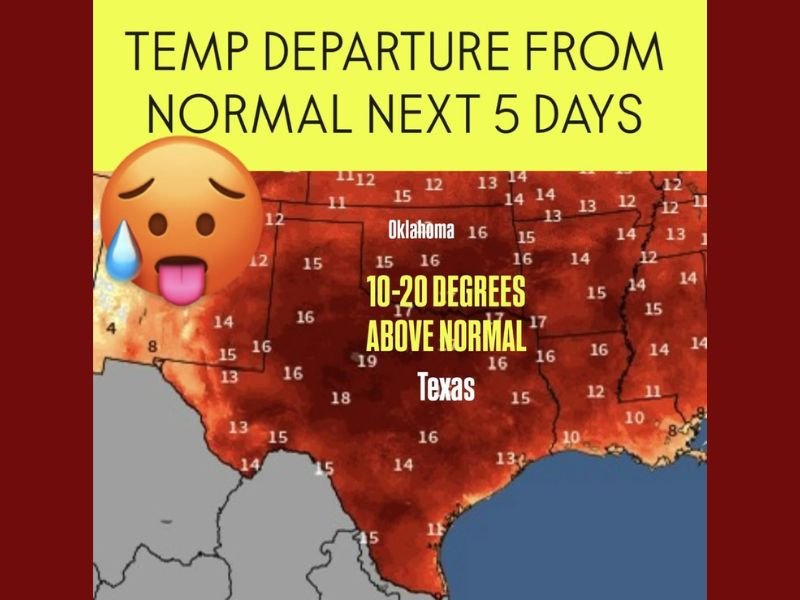
Texas and Oklahoma to Experience 10–20 Degrees Above Normal Temperatures Before Thanksgiving Cold Front
DALLAS, Texas — Residents across Texas and Oklahoma are experiencing an unseasonably warm spell this week, with temperatures soaring 10 to 20 degrees above normal, according to new regional weather data. The heat surge is expected to last through the next five days, before a powerful cold front begins to move in during Thanksgiving week.
Meteorologists say a stubborn ridge of high pressure has parked over the Southern Plains, trapping warm, dry air across the region and keeping daytime highs far above typical mid-November averages.
Temperatures 10–20 Degrees Above Normal
Weather models show much of Texas, Oklahoma, and parts of Arkansas and Louisiana running significantly warmer than average through the weekend.
- North Texas (Dallas–Fort Worth area): Highs in the low-to-mid 80s, roughly 15°F above seasonal norms.
- Central and South Texas (Austin, San Antonio, Houston): Some locations could briefly touch 90°F, which is more typical for early September than mid-November.
- Oklahoma City and Tulsa: Highs around 78–82°F, with overnight lows staying near the 60s — a full 20 degrees warmer than normal for this time of year.
“We’re seeing a persistent ridge pattern that’s allowing warm air to build and stay in place,” forecasters explained. “This is a classic pre-front setup — the calm before the cold.”
The National Weather Service (NWS) noted that while the heat wave is short-lived, it’s significant given how far temperatures are deviating from climatological averages.
Why the Sudden Heat Surge?
This burst of warmth is tied to an upper-level high-pressure dome that has dominated the Southern Plains for several days. The system has limited cloud cover, allowing abundant sunshine to drive daytime heating.
At the same time, southerly winds from the Gulf of Mexico are drawing in warm, humid air, reinforcing the heat and keeping nighttime temperatures elevated.
Forecasters say this setup will hold steady through early next week, before a strong Arctic cold front pushes southward.
Big Cooldown Expected by Thanksgiving Week
While residents are currently experiencing near-summerlike warmth, long-range models are tracking a major cold front expected to arrive around November 25–27. The front could drop temperatures by 20–30 degrees in just 24 hours, signaling a dramatic shift to late-fall conditions.
Meteorologists are also monitoring signs of a polar air surge that may bring frost and freezing conditions to parts of Oklahoma, northern Texas, and the Midwest just after Thanksgiving.
“It’s rare to see this kind of temperature swing so close to the holiday,” said a Dallas-area forecaster. “Travelers should prepare for a sharp transition from t-shirt weather to heavy jackets within a day or two.”
Potential Weather Impacts
Though the warm stretch has provided pleasant outdoor conditions, it could also lead to minor weather-related concerns, including:
- Increased fire danger across dry western parts of Texas and Oklahoma due to low humidity and gusty winds.
- Allergy flare-ups, as warmer air extends the ragweed and grass pollen season.
- Energy demand spikes in urban centers as air conditioning use briefly rises again.
Additionally, the incoming cold front could bring scattered storms or gusty winds when it arrives late next week.
Temperature Outlook by Region
| Region | Average High (°F) | Expected High This Week (°F) | Departure from Normal (°F) |
|---|---|---|---|
| North Texas | 67 | 84 | +17 |
| South Texas | 72 | 89 | +17 |
| Oklahoma City | 63 | 81 | +18 |
| Tulsa | 62 | 80 | +18 |
| East Texas | 68 | 85 | +17 |
This warmth follows a mild fall pattern that has delayed the first significant cold outbreak for much of the South and Midwest.
Looking Ahead: From Shorts to Sweaters
By the middle of next week, cooler air will begin filtering into the Plains and Midwest, gradually spreading southward. The expected Thanksgiving cold front could bring a wide range of temperatures, with highs in the 40s and 50s by late November — a stark contrast from this week’s 80s and 90s.
“It’s a roller coaster pattern,” meteorologists said. “We’ll go from summerlike warmth to a winter preview in less than a week.”
Travelers planning holiday trips across the Southern Plains are advised to monitor forecast updates closely, as the incoming front may impact flights and road travel due to wind shifts and storm activity.
Have you noticed the heat wave in your area? Share your photos and local weather updates at NapervilleLocal.com.

I’ve lived in Naperville long enough to see how quickly our community changes — from new developments downtown to sudden shifts in our Midwest weather. Reporting on Naperville news and daily forecasts gives me the chance to keep neighbors informed about what really matters. My goal is simple: deliver clear, timely updates so you always know what’s happening in our city and what to expect from the skies above.