
Texas and the Southern Plains Face Potential Arctic Blast and Icy Winter Weather as January 23–25 Pattern Comes Into Focus
TEXAS — Forecast guidance is increasingly aligning around a significant Arctic blast arriving Friday night and extending into next weekend, with the potential for wintry precipitation developing as cold air collides with an overrunning weather system. While details remain uncertain this far out, meteorologists say the overall signal points to a major pattern shift toward prolonged cold with at least some winter weather risk.
Why This Late-January Setup Has Meteorologists Concerned
Multiple global forecast models are now showing a strong surge of Arctic air pushing south at the same time a low-pressure system develops over the southern United States. This type of setup is known as an overrunning pattern, where warmer moisture rides up and over shallow cold air at the surface — a classic recipe for freezing rain, sleet, or icy conditions.
What stands out is that all major guidance sources are seeing this signal, not just one model run.
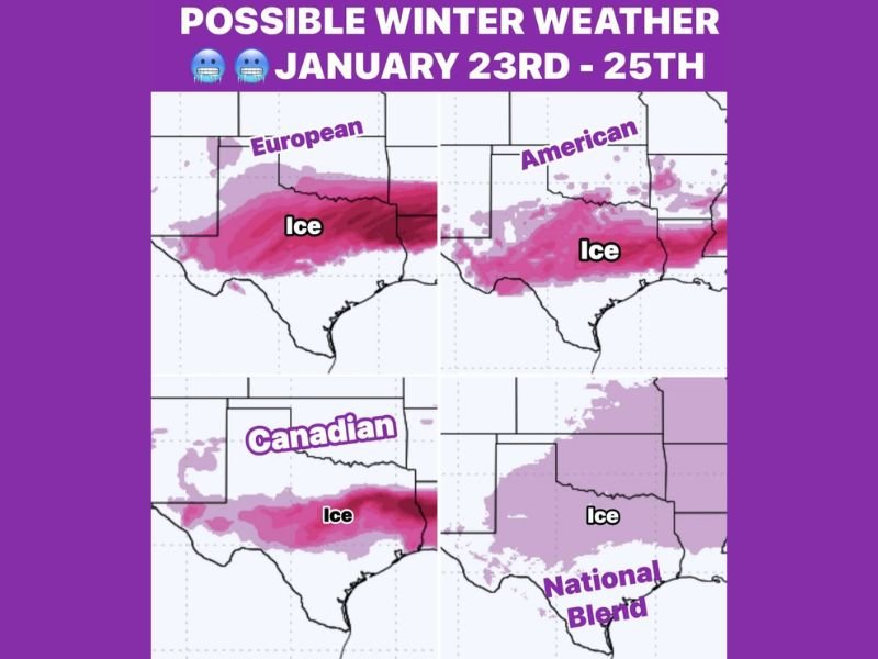
What the Major Forecast Models Are Showing
At this stage, the European (ECMWF), American (GFS), Canadian models, and the National Blend are all indicating a chilly rain scenario that could become cold enough for frozen precipitation, especially across parts of Texas and nearby states.
Key points meteorologists are watching closely include:
- Cold air depth — determining whether precipitation falls as rain, sleet, or freezing rain
- Storm track and timing — small shifts could greatly change who sees ice versus plain rain
- Duration of cold — guidance suggests an extended cold period, not just a brief snap
While the exact placement of ice remains uncertain, the consistency across models is an early warning sign.
Timing: When Impacts Could Begin
Current projections suggest:
- Arctic air arrives Friday night
- Wintry precipitation potential increases between January 23 and January 25
- Cold conditions may linger beyond the weekend
Because this system is still several days out, meteorologists caution that precise impacts cannot yet be pinned down, but confidence is growing that some form of winter weather is likely somewhere in the region.
Why Confidence Is Growing Even Without Specific Details
Even though it is too early to determine exactly who gets ice, sleet, or just cold rain, the broader pattern is becoming clearer. All guidance points toward:
- A sharp temperature drop
- A prolonged cold stretch
- A non-zero risk of frozen precipitation
This combination strongly suggests meaningful winter impacts are possible, especially if surface temperatures remain locked below freezing while moisture moves in overhead.
What to Watch in the Days Ahead
Forecasts over the coming week will focus on:
- Refining temperature profiles near the surface
- Determining how far south and east the cold air pushes
- Identifying the most likely ice-impact zones
Even minor shifts in the forecast could make a big difference in road conditions and travel safety.
Bottom Line
A major late-January pattern shift is underway, bringing Arctic cold and the potential for wintry precipitation to parts of Texas and the southern Plains. While it is too early for exact impact maps, the agreement among multiple forecast models makes this a system worth watching closely. Stay weather-aware as forecasts evolve, and follow continued updates and discussion at NapervilleLocal.com.

I’ve lived in Naperville long enough to see how quickly our community changes — from new developments downtown to sudden shifts in our Midwest weather. Reporting on Naperville news and daily forecasts gives me the chance to keep neighbors informed about what really matters. My goal is simple: deliver clear, timely updates so you always know what’s happening in our city and what to expect from the skies above.