
Texas Cold Front Brings Sudden Winter Return Across North Central Texas With Freeze, 50 MPH Winds and 20s Wind Chills
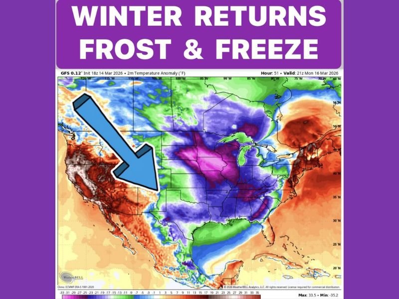
DALLAS–FORT WORTH, TEXAS — A powerful cold front is expected to sweep across North Central Texas Sunday afternoon, bringing a sharp and sudden return to winter conditions after warm temperatures in the 80s earlier in the day. The incoming front is forecast to trigger rapidly falling temperatures, strong wind gusts up to 50 mph and widespread freezing conditions by early Monday morning.
Meteorologists say the dramatic change could catch many residents off guard as springlike warmth gives way to freezing overnight temperatures across several parts of the region.
Strong Cold Front Arrives Sunday Afternoon
Forecasters indicate the cold front will move into North Central Texas around 1 PM Sunday, marking the start of a rapid temperature drop across the region. Before the front arrives, many areas will still be experiencing warm afternoon temperatures in the low 80s. However, conditions will change quickly once the front pushes through.
Strong north winds are expected to increase behind the front, with wind gusts potentially reaching 50 mph, making the air feel significantly colder as temperatures fall throughout the afternoon and evening. Meteorologists say the combination of strong winds and falling temperatures will signal the start of a brief but sharp winter return across the region.
Freezing Temperatures Expected North of Highway 380
By early Monday morning, temperatures across parts of North Central Texas are forecast to drop to at or below freezing, especially in areas located north of Highway 380. Residents in these northern areas are being urged to bring sensitive plants indoors or cover them to prevent frost damage.
Cold air moving south across the Plains will allow freezing conditions to spread overnight, with some communities experiencing temperatures hovering around the freezing mark for several hours before sunrise. The cold snap may be brief, but it could still create problems for early spring vegetation.
Wind Chills Could Drop Into the 20s Across the Region
In addition to the freezing temperatures, strong winds will make conditions feel even colder across much of North Central Texas. Meteorologists expect wind chills to fall into the 20s across widespread areas, particularly during the early morning hours Monday when the coldest air settles over the region.
These colder wind chill values will make it feel more like mid-winter despite the calendar approaching late March. Travelers and commuters heading out early Monday may notice the sudden difference compared to the warm conditions experienced just a day earlier.
Cold Start Monday Before Gradual Warmup Later in the Week
Temperatures Monday afternoon are expected to recover slightly but will remain relatively cool compared to recent warmth. Forecast highs are projected to reach only the 50s across most areas, while northern parts of North Central Texas may stay in the 40s throughout the day.
Another chilly night is also possible. Many areas could once again approach near-freezing temperatures Tuesday morning before the pattern begins shifting back toward warmer conditions later in the week. Meteorologists say the cold outbreak is part of a broader weather pattern pushing colder air southward across parts of the central United States.
While the winterlike conditions will likely be temporary, residents across North Central Texas should prepare for freezing temperatures, strong winds and much colder air to start the week. Stay with NapervilleLocal.com for continuing weather coverage and updates on major forecast changes impacting Texas and weather patterns across the United States.

I’ve lived in Naperville long enough to see how quickly our community changes — from new developments downtown to sudden shifts in our Midwest weather. Reporting on Naperville news and daily forecasts gives me the chance to keep neighbors informed about what really matters. My goal is simple: deliver clear, timely updates so you always know what’s happening in our city and what to expect from the skies above.