
Texas Faces Late-Night Severe Thunderstorm Threat With Risk of Hail, Strong Winds, and Isolated Tornadoes
TEXAS — Residents across central and eastern Texas are being urged to stay alert this evening as forecasters warn of severe thunderstorms developing along a cold front, capable of producing large hail, damaging winds, and possibly an isolated tornado.
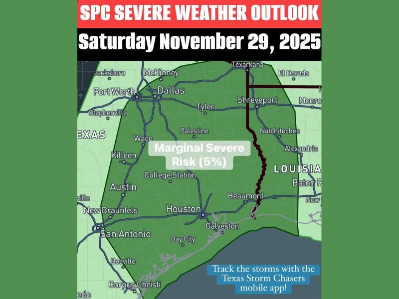
The Storm Prediction Center (SPC) has placed much of the state under a Level 1 out of 5 “marginal risk” for severe weather through tonight, November 29, 2025. Areas included in the alert range from Dallas and Tyler to Austin, Houston, College Station, and Beaumont, with storms expected to intensify through late evening hours.
Late-Night Storms Could Pack a Punch
According to the latest forecast from Texas Storm Chasers, isolated severe storms are likely to develop late this afternoon into the night, tracking eastward with the advancing cold front.
“Storms may produce large hail, damaging wind gusts, and an isolated tornado as the cold front pushes through,” meteorologist Jason from TSC reported. “Once the front clears your area, the severe threat will quickly diminish — but much colder air will follow.”
The cold front’s rapid movement could bring dramatic temperature drops overnight, along with strong post-frontal winds capable of causing minor damage or blowing around unsecured outdoor decorations and inflatables.
Cities Under the Marginal Risk Zone
Forecasters say the following regions are most at risk for severe storms late Friday and into early Saturday morning:
- Dallas–Fort Worth area
- Tyler and Palestine
- Austin and College Station
- Houston, Beaumont, and Galveston
While the overall risk level is marginal, meaning widespread severe weather isn’t expected, any isolated storm could turn severe quickly, particularly in zones where moisture and instability remain high.
Timing and What to Expect
The window for strong to severe storms will likely extend from late Friday afternoon through early Saturday morning. Storms will first impact North and Central Texas, then spread southeastward toward the Gulf Coast by midnight.
Behind the front, wind gusts could reach 40–50 mph, with rapidly falling temperatures expected by sunrise Saturday.
“People should be cautious, especially if driving tonight,” forecasters warned. “Strong crosswinds, slick roads, and reduced visibility could make travel hazardous.”
How Residents Can Stay Safe
- Secure outdoor items such as lawn furniture, garbage bins, and holiday inflatables.
- Avoid parking vehicles under trees or near power lines in case of wind damage.
- Have multiple ways to receive weather alerts, including NOAA radios or mobile apps.
- If a tornado warning is issued, seek shelter immediately in an interior room on the lowest floor.
Calm Returns After the Front
Once the cold front moves through overnight, the severe threat will taper off — replaced by much colder and drier air across Texas. Temperatures are expected to fall sharply by Saturday morning, marking the arrival of one of the season’s first significant cool-downs.
Meteorologists advise Texans to enjoy the relief from heat but to remain cautious tonight as the storms move across the region.
Stay updated on weather developments and local forecasts by visiting NapervilleLocal.com for the latest regional coverage and community alerts.

I’ve lived in Naperville long enough to see how quickly our community changes — from new developments downtown to sudden shifts in our Midwest weather. Reporting on Naperville news and daily forecasts gives me the chance to keep neighbors informed about what really matters. My goal is simple: deliver clear, timely updates so you always know what’s happening in our city and what to expect from the skies above.