
Texas, Louisiana, Mississippi, Alabama and Florida Gulf Coast Could See Rare ‘Gulf Effect Snow’ as Arctic Air Pushes South
UNITED STATES — A rare winter weather setup is drawing attention across the Texas, Louisiana, Mississippi, Alabama, and Florida Gulf Coast, where an intense surge of Arctic air could briefly create conditions favorable for a phenomenon known as “Gulf Effect Snow.”
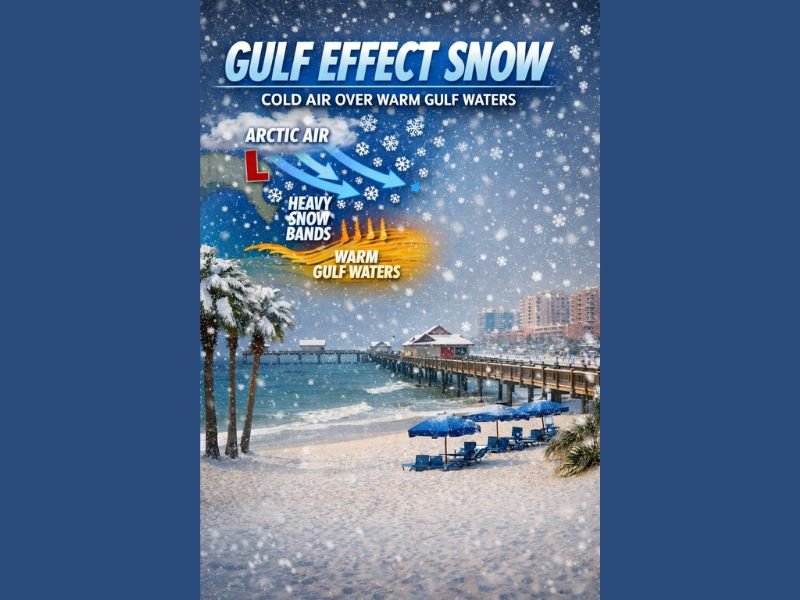
Meteorologists say the pattern unfolding this weekend is unusual but real, as extremely cold air is forecast to move south over the warm waters of the Gulf of Mexico, a combination that can occasionally generate coastal snow flurries in parts of the Deep South.
Why ‘Gulf Effect Snow’ Is Even Possible
Gulf Effect Snow works on the same principle as lake-effect snow in the Great Lakes. When very cold air passes over much warmer water, heat and moisture are transferred into the atmosphere. Under the right conditions, that moisture can fall as snow once it reaches land.
While lake-effect snow happens frequently in northern states, Gulf Effect Snow is extremely rare, requiring unusually strong Arctic air and precise atmospheric alignment. Meteorologists note that this weekend’s cold outbreak may finally meet those thresholds.
Timing and Areas Being Watched Closely
Forecast discussions suggest the best window for any Gulf Coast flurries would be late Saturday night into early Sunday, when the coldest air arrives. Coastal areas of Texas, Louisiana, Mississippi, Alabama, and parts of Florida are being monitored, especially locations closest to the shoreline where Gulf moisture is most accessible.
Any snow that develops would be brief, scattered, and highly localized, with little to no accumulation expected.
What Makes This Cold Outbreak Different
Forecasters say this Arctic intrusion stands out because of how far south the cold air is pushing. Temperatures are expected to drop well below normal across the Gulf states, increasing the contrast between land air temperatures and warm Gulf waters. That sharp temperature difference is what raises the possibility — however slim — of snowflakes along parts of the coast.
What Residents Should Expect
Officials stress that this is not a major snow event, and most people will not see snowfall. However, dangerously cold temperatures and wind chills remain the primary concern, particularly overnight. Even if snow does not materialize, the setup itself is notable due to how rare such conditions are along the Gulf Coast.
For continued coverage of rare winter weather patterns, Arctic outbreaks, and national cold trends, stay connected with NapervilleLocal.com.

I’ve lived in Naperville long enough to see how quickly our community changes — from new developments downtown to sudden shifts in our Midwest weather. Reporting on Naperville news and daily forecasts gives me the chance to keep neighbors informed about what really matters. My goal is simple: deliver clear, timely updates so you always know what’s happening in our city and what to expect from the skies above.