
Texas, Louisiana, Mississippi, Alabama, and Georgia Face Cold Weekend as Snow Threat Shifts East of Southeast Texas
United States — A strong cold front is expected to sweep through Texas Friday evening, delivering the first light freeze of 2026 to parts of the state, while snow chances increase farther east across Louisiana, Mississippi, Alabama, Georgia, and parts of the Southeast as cold air overlaps with deeper moisture.
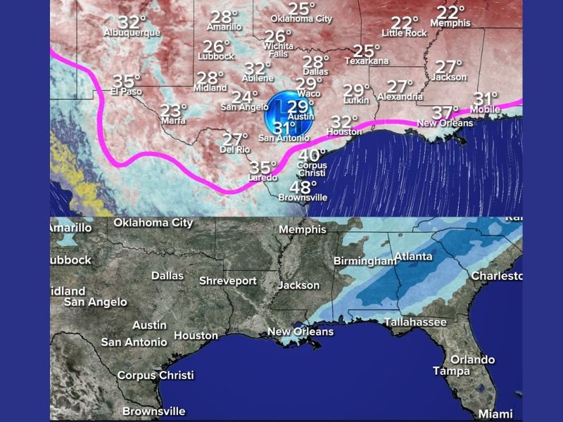
Forecast guidance continues to show a sharp divide between cold but dry conditions in Southeast Texas and a better snow setup east of the region, closer to the central and eastern Gulf Coast.
Cold Front Arrival and Freeze Risk in Texas
The cold front is on track to reach Houston and Southeast Texas Friday evening, ushering in significantly colder air overnight. Temperatures are expected to drop low enough to support snow thermally, but moisture remains the limiting factor.
Key points for Texas include:
- Cold enough for snow Saturday night, especially inland
- Little to no moisture available to generate snow showers
- High confidence in cold conditions, low confidence in snowfall
For most of Southeast Texas, the most likely outcome is cold air without snow.
Why Snow Chances Are Higher East of Texas
Farther east, the forecast becomes more favorable for snow as freezing temperatures and moisture overlap more effectively. Models show better precipitation coverage stretching from Louisiana eastward across Mississippi, Alabama, Georgia, and into the Southeast.
This region sits closer to the core of the moisture plume associated with the system, increasing the likelihood of snow showers or light accumulations, especially late Saturday night into Sunday.
One Model Suggests Coastal Snow Potential
While most guidance keeps Southeast Texas dry, one computer model continues to show a low-probability scenario in which enough moisture sneaks south of Interstate 10 near the coast early Sunday morning to produce light snow showers. This remains a low-confidence outcome, but forecasters are monitoring it given the region’s history of unexpected winter surprises.
What Residents Should Expect This Weekend
Based on current data, expected impacts include:
- Freezing temperatures across much of Texas
- Higher snow potential east of Texas, closer to the central Gulf Coast
- Minimal snow risk in Houston and surrounding areas
- Possible light accumulations farther east, depending on final storm track
Even where snow does not fall, the cold air alone could affect travel, outdoor plans, and sensitive vegetation.
Forecast Still Being Monitored
Meteorologists emphasize that small shifts in moisture placement could still alter snow chances, especially near the Gulf Coast. Updates will continue as the system approaches and higher-resolution data becomes available.
For continued updates on cold fronts, snow potential, and weekend weather impacts across the South and Southeast, follow ongoing coverage from napervillelocal.com, where we track developing weather threats and explain what they mean for local communities.

I’ve lived in Naperville long enough to see how quickly our community changes — from new developments downtown to sudden shifts in our Midwest weather. Reporting on Naperville news and daily forecasts gives me the chance to keep neighbors informed about what really matters. My goal is simple: deliver clear, timely updates so you always know what’s happening in our city and what to expect from the skies above.