
Texas, Louisiana, Mississippi, Alabama, Georgia and Florida Face a Sharp Temperature Flip as Warm Gulf Air Collides With a Strong Cold Front
UNITED STATES — A broad stretch of the Gulf Coast is enjoying a burst of early warmth, with many communities across Texas, Louisiana, Mississippi, Alabama, Georgia, and Florida sitting in the 60s and 70s, but the latest forecast messaging warns that a strong cold front is lining up to bring a rapid “back-to-winter” shift early next week.
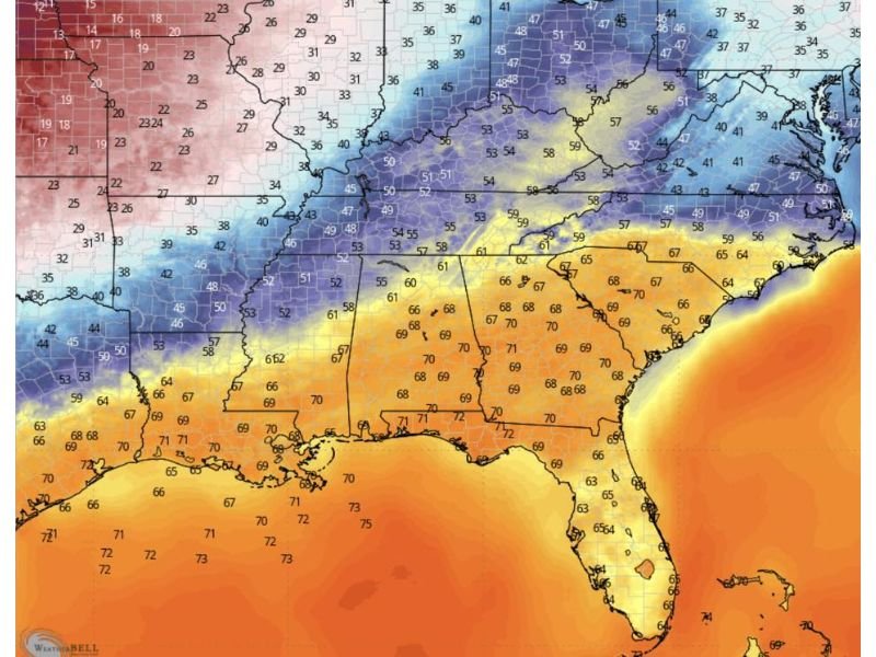
Temperature maps show a clear boundary: mild, humid air hugging the Gulf while much colder air is positioned just to the north across parts of the South and lower Midwest. That kind of setup often leads to a quick pattern change, where one day feels springlike and the next brings coats back out—especially once the front sweeps through.
Warm, Humid Weekend Air Spreads Across the Gulf Coast
Across much of the Gulf-facing region, temperatures are running comfortably warm. Several areas in southern Texas and Louisiana are in the upper 60s to low 70s, with similar readings extending eastward into Mississippi, Alabama, southern Georgia, and parts of Florida.
This warm zone is most pronounced near the immediate Gulf, where water temperatures and southerly flow help keep nights mild and afternoons noticeably warmer than average for late winter. For residents, the weekend may feel like a brief spring preview—pleasant for outdoor plans, but also a sign that the atmosphere is primed for change as the boundary between warm and cold air tightens.
Cold Front Next Week Could Bring “February” Back Fast
Forecast commentary tied to this setup emphasizes that the warmth is not expected to last. The incoming cold front is expected to cut through the region next week, replacing the mild air with much colder conditions.
On the temperature map, colder readings in the 30s and 40s are already present north of the Gulf states, showing the reservoir of cold air that can surge south once the front pushes through. When a front like this arrives, temperatures can drop quickly within a few hours—often accompanied by gusty winds that make it feel even colder.
What to Watch: Frost, Freeze Pockets, and Planning Impacts
While exact low temperatures will vary by city, this type of transition can create frost and freeze risk in the coldest inland pockets, especially away from the immediate coastline. Residents should keep an eye on:
- Overnight lows after the front passes
- Frost potential for sensitive plants and early gardens
- Pet and pipe protection in colder rural areas
- Quick changes in comfort and heating needs as temperatures fall
The key takeaway is timing: a warm weekend can lead to a false sense of spring, but the broader pattern suggests colder air is still capable of returning sharply.
For more weather updates written in a clear, local-news style, visit NapervilleLocal.com for ongoing coverage and practical planning takeaways.

I’ve lived in Naperville long enough to see how quickly our community changes — from new developments downtown to sudden shifts in our Midwest weather. Reporting on Naperville news and daily forecasts gives me the chance to keep neighbors informed about what really matters. My goal is simple: deliver clear, timely updates so you always know what’s happening in our city and what to expect from the skies above.