
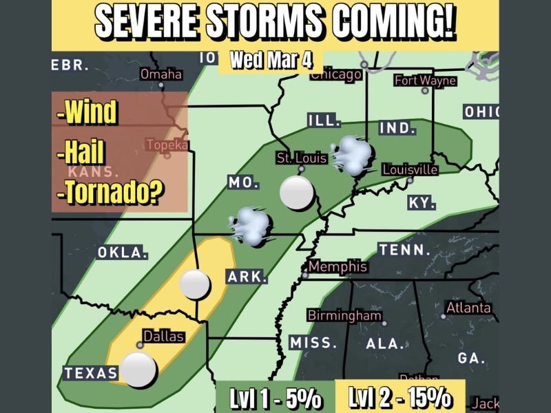
Texas, Oklahoma and Arkansas Face Elevated Hail and Wind Threat Wednesday as Multi-Day Severe Pattern Expands Toward Missouri and Illinois
TEXAS, OKLAHOMA AND ARKANSAS — An active stretch of stormy weather is set to begin Wednesday, bringing a more concentrated severe weather threat to parts of north Texas, Oklahoma and Arkansas, with additional storms possible into Missouri and Illinois as the system evolves.
Forecasters indicate large hail remains the primary concern, especially with elevated supercell thunderstorms. While overall tornado potential appears limited, it is not zero. Meteorologists caution that whenever sufficient wind shear is present to support rotating storms — even elevated ones — isolated tornado development cannot be completely ruled out.
Wednesday Focus: Hail and Damaging Wind Potential
The primary risk zone for Wednesday, March 4, includes Dallas, Wichita Falls, central and eastern Oklahoma, and western Arkansas. A highlighted corridor stretches from north-central Texas into Oklahoma and Arkansas, where storms may organize during the afternoon and evening hours.
Within this region, the main hazards are expected to be large hail and damaging straight-line winds. Elevated supercells can produce significant hail even when surface conditions are not ideal for tornado formation.
Farther north and east, a broader 5% risk area extends into Missouri, southern Illinois, Indiana and Kentucky, including cities such as St. Louis and Louisville. Storm intensity in these areas may be lower compared to the core risk zone to the south, but gusty winds and hail remain possible.
Tornado Potential Described as “Non-Zero”
Although the setup does not appear overwhelmingly favorable for widespread tornado activity, forecasters note that tornado potential is not completely off the table. When wind shear is strong enough to support rotating updrafts, even marginal environments can produce brief or isolated tornadoes.
This means residents in the higher-risk corridor across north Texas and Oklahoma should stay weather-aware, particularly during peak storm development hours.
More Severe Weather Possible Thursday and Friday
Wednesday is only the beginning of what could be a multi-day severe pattern. Additional disturbances are expected to move through the region Thursday and Friday, potentially bringing renewed severe weather concerns.
When multiple systems track across the Southern Plains in quick succession, atmospheric conditions can remain primed for organized storms. Each wave may reinforce moisture and instability, increasing the likelihood of repeated storm development.
Communities across Texas, Oklahoma, Arkansas and portions of Missouri and Illinois should monitor updates throughout the week as details become clearer. Timing, storm mode and exact impact zones may shift as newer data becomes available.
Early March often marks a transition into a more active severe weather period across the Southern Plains and lower Midwest. This week’s pattern appears consistent with that seasonal shift. For continued coverage of developing severe weather threats and regional updates, visit NapervilleLocal.com for the latest reports and preparedness information.

I’ve lived in Naperville long enough to see how quickly our community changes — from new developments downtown to sudden shifts in our Midwest weather. Reporting on Naperville news and daily forecasts gives me the chance to keep neighbors informed about what really matters. My goal is simple: deliver clear, timely updates so you always know what’s happening in our city and what to expect from the skies above.