
Texas, Oklahoma, and Arkansas to Face Sharp Temperature Drop Sunday as Cold Blast Pushes Into Southern Plains
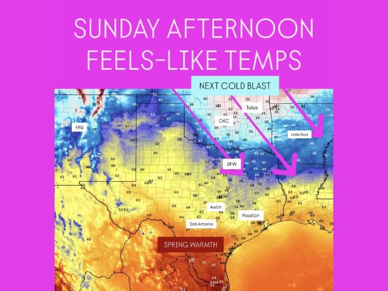
DALLAS, TEXAS — Another strong cold front will surge through the Southern Plains on Sunday, dramatically dropping temperatures across Texas, Oklahoma, and Arkansas. Meteorologists say the sharp cold blast will arrive by midday, sending “feels-like” temperatures tumbling from the 60s and 70s into the 30s and 40s behind the front.
Cold Front Sweeps Through Southern Plains Sunday
The latest forecast maps show a distinct boundary stretching from Oklahoma City to Dallas and Little Rock, marking the leading edge of a powerful Arctic air mass. By Sunday afternoon, areas north of the front will experience much colder conditions, while locations farther south — such as Austin, San Antonio, and Houston — will briefly hold onto spring-like warmth before cooling down late in the day.
Temperatures behind the front are expected to fall rapidly into the 30s and low 40s across northern Texas and Oklahoma, with wind chills making it feel even colder. Meanwhile, central and southern Texas will see readings in the 60s to low 70s early Sunday, but the chill will arrive by evening as the front continues southward.
Meteorologists describe this setup as a “classic winter clash” — cold, dense air from the north colliding with warm Gulf moisture, creating a steep temperature gradient across the Southern Plains.
Feels-Like Temperatures Show Stark Contrast
Forecast data indicates that Dallas-Fort Worth (DFW) could see a 20- to 25-degree temperature drop between morning and afternoon. At the same time, Oklahoma City and Tulsa will feel temperatures in the upper 20s to low 30s once the front passes, with gusty north winds intensifying the chill.
Across Arkansas, areas like Little Rock will transition from mild mid-50s early in the day to the low 40s by evening, with wind chills dipping into the 30s. Farther west, Amarillo and Lubbock will stay firmly in the cold sector, struggling to reach above freezing throughout Sunday.
Monday Morning Freeze Expected in Northern Areas
Behind the front, clear skies and calm winds Monday morning will allow temperatures to plunge further. Widespread lows in the mid-20s to low 30s are expected across northern Texas and Oklahoma, marking another freeze event for early December. The National Weather Service warns that patchy frost could extend into central Texas by dawn, while parts of Arkansas may also experience light freezing conditions.
Residents are urged to protect plants, pets, and outdoor plumbing as temperatures drop overnight. The quick transition from warm to freezing conditions could also cause icy patches on bridges or elevated roads early Monday.
Outlook: More Temperature Swings Ahead
Forecasters say this cold snap is part of an active 10–15 day pattern of alternating warm and cold surges across the central United States. After a brief warm-up midweek, another potential cold front could arrive late next weekend, keeping the Southern Plains in a rollercoaster pattern of highs and lows typical of December.
Residents should stay updated on forecast changes and prepare for rapidly shifting conditions over the next several days. For ongoing weather coverage, forecasts, and regional alerts, visit NapervilleLocal.com for the latest updates.

I’ve lived in Naperville long enough to see how quickly our community changes — from new developments downtown to sudden shifts in our Midwest weather. Reporting on Naperville news and daily forecasts gives me the chance to keep neighbors informed about what really matters. My goal is simple: deliver clear, timely updates so you always know what’s happening in our city and what to expect from the skies above.