
Texas, Oklahoma and Missouri Placed in Day 6 Severe Storm Risk as Friday Night Threat Builds Across Southern Plains
TEXAS, OKLAHOMA AND MISSOURI — The Storm Prediction Center has added a Day 6 severe weather outlook for Friday night, highlighting a broad corridor from north and central Texas through Oklahoma into Kansas and Missouri as confidence grows in the potential for organized thunderstorms late this week.
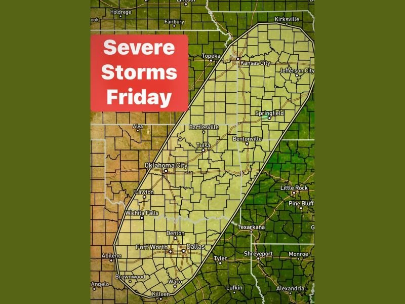
The projected risk area stretches from Killeen, Waco, Fort Worth and Dallas northward through Oklahoma City, Tulsa and Bartlesville, and continues into Kansas City, Jefferson City and Springfield, Missouri. This elongated corridor suggests a developing storm system capable of affecting multiple population centers if conditions align.
Friday Night Timing Comes Into Focus
Forecasters indicate that the severe threat appears most likely Friday night, rather than earlier in the day. While details remain subject to change, the inclusion of a Day 6 outlook signals that atmospheric ingredients are beginning to organize in a way that supports potential severe storm development.
This risk does not guarantee widespread severe weather, but it does indicate growing confidence that organized thunderstorms may develop across the Southern Plains and Mid-Missouri Valley region. Residents across major metro areas, including Dallas-Fort Worth, Oklahoma City and Kansas City, should monitor updates as the week progresses.
A Series of Disturbances Leading Up to Friday
The Friday setup will not arrive in isolation. Forecast discussions point to a series of disturbances moving through the region, with the first wave expected to arrive late Wednesday afternoon into Wednesday night. That earlier system may help prime the atmosphere ahead of the stronger late-week disturbance.
Each successive system can influence moisture return, instability levels and storm organization potential. As additional disturbances move across Texas and Oklahoma midweek, forecasters will evaluate how those systems shape Friday’s severe weather environment.
Because this is still several days away, specific hazards such as hail size, wind intensity or tornado potential have not yet been clearly defined. However, the broad highlighted region suggests the possibility of strong to severe thunderstorms capable of producing damaging impacts.
Monitoring the Pattern as Confidence Grows
Day 6 outlooks are issued when early model guidance consistently signals a severe weather setup. As Friday approaches, outlook categories may be refined and adjusted based on updated data regarding storm timing, wind shear and instability.
Communities across north and central Texas, central and eastern Oklahoma, southeastern Kansas and western to central Missouri should stay weather-aware this week. Evening severe weather can present additional challenges, particularly if storms develop after sunset.
Meteorologists will continue evaluating storm track, frontal placement and moisture return from the Gulf in the coming days. Updates are expected as forecast confidence improves.
For continued regional weather coverage and developing storm updates, visit NapervilleLocal.com for the latest reports and preparedness information.

I’ve lived in Naperville long enough to see how quickly our community changes — from new developments downtown to sudden shifts in our Midwest weather. Reporting on Naperville news and daily forecasts gives me the chance to keep neighbors informed about what really matters. My goal is simple: deliver clear, timely updates so you always know what’s happening in our city and what to expect from the skies above.