
Texas–Oklahoma Arctic Front Expected to Send Freezing Temperatures Toward the Gulf Coast Early Next Week
TEXAS — A stronger arctic cold front sweeping across the Central United States is now projected to push deep into Texas and the Gulf Coast region, raising the possibility of Houston’s first freeze of the season early next week. Forecast maps show temperatures plunging into the mid-30s across Houston, with areas north and west of the city at greater risk for hitting 32°F or below as early as Monday morning.
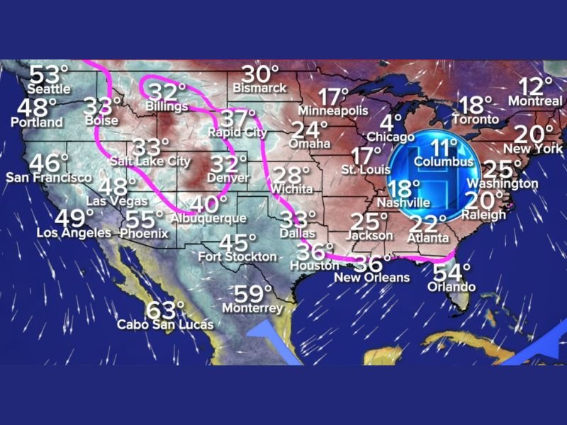
What the Latest Forecast Maps Reveal
Meteorologists are tracking a powerful surge of arctic air descending from the Northern Plains into the Midwest, extending through Oklahoma, North Texas, and Southeast Texas by late Sunday. The forecast graphic highlights widespread lows between 30°F and 37°F across cities like Denver (32°), Salt Lake City (33°), Billings (32°), and Wichita (28°) — a clear indication of the dense cold pool building behind the front.
By Monday at 6 a.m., the cold dome centers over Ohio, with surrounding regions such as Chicago (4°), Minneapolis (17°), St. Louis (17°), and Atlanta (22°) experiencing a sharp and sustained drop. Although the Houston region sits just south of the core arctic air, the freeze line appears close enough that a brief light freeze cannot be ruled out for parts of Southeast Texas.
Forecasters emphasize that Houston typically records its first seasonal freeze in early to mid-December, meaning this pattern aligns closely with historical averages — but the strength of the incoming front could bring colder-than-usual conditions for this time of year.
How the Arctic Front Could Affect the Houston Area
Houston’s projected low of 36°F places the city near the edge of freezing potential, while surrounding communities — particularly northwest Harris County, Montgomery County, and rural stretches west of I-45 — could briefly dip to 32°F under clear skies and lighter winds.
With cold, dry air blowing in behind the front, conditions will favor overnight radiational cooling, which increases the risk of spot-freezing in sheltered or low-lying areas. While the event is expected to be short-lived, any freeze would still be significant, especially for sensitive plants, exposed pipes, and outdoor pets.
The front is also expected to bring increased rain chances on Sunday as warm, moist Gulf air interacts with the advancing cold boundary. After the front passes, skies should clear quickly, allowing colder nighttime conditions to settle in.
What Residents Should Do to Prepare
Even though this freeze risk is described as “brief and light,” Houston-area families and businesses are encouraged to take standard early-season cold precautions:
- Protect plants, especially tropical varieties common across Southeast Texas.
- Wrap exposed pipes, particularly outdoor faucets or plumbing in poorly insulated areas.
- Bring pets indoors, as rapidly dropping temperatures can be harmful even if conditions remain above freezing.
- Check space heaters now to ensure safe operation before colder conditions arrive.
By Monday afternoon, temperatures are expected to rebound modestly, but the region will remain under cooler-than-normal conditions for several days.
Why This Arctic Front Matters for the Gulf Coast
While December freezes are not rare, the strength of this particular arctic front — capable of driving temperatures into the teens and single digits across the Midwest and Northeast — underscores how far south the cold air is expected to reach. For the Gulf Coast, this event signals the first major winter push of the season and offers clues about potential weather patterns ahead.
If similar fronts continue to dip southward in the coming weeks, Southeast Texas could see a colder-than-average start to winter, with additional freeze threats possible before the end of December.
As winter weather continues to develop across multiple states, stay connected to NapervilleLocal.com for timely coverage, temperature updates, and important seasonal safety guidance for communities across the region.

I’ve lived in Naperville long enough to see how quickly our community changes — from new developments downtown to sudden shifts in our Midwest weather. Reporting on Naperville news and daily forecasts gives me the chance to keep neighbors informed about what really matters. My goal is simple: deliver clear, timely updates so you always know what’s happening in our city and what to expect from the skies above.