
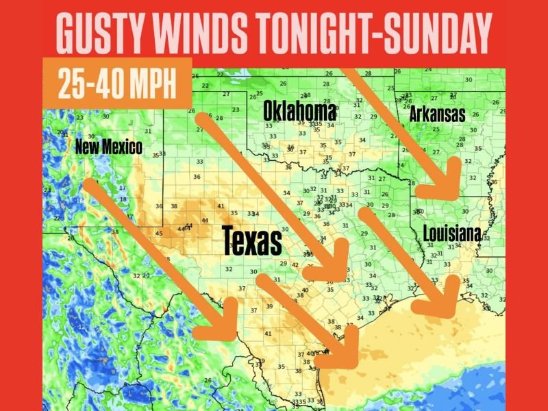
Texas, Oklahoma, Arkansas, Louisiana and New Mexico Facing 25–40 MPH Gusty Winds Behind Strong Cold Front
TEXAS — A surge of strong northerly winds will sweep across Texas, Oklahoma, Arkansas, Louisiana, and New Mexico tonight through Sunday, bringing gusts between 25 and 40 mph and causing wind chills to drop to much colder values across the region.
Gusty Winds Expected Through Sunday Morning
The forecast map highlights a large swath of the Southern Plains and Lower Mississippi Valley where persistent northerly winds will increase overnight.
Wind gusts are expected to reach 25–40 mph, a direct result of the cold front pushing south across the region.
Such wind speeds can rapidly decrease temperatures, making early Sunday morning feel significantly colder than the actual air temperature.
Cold Front Driving the Change
Behind the front, colder air is already spilling through the region:
- Texas: widespread gusty conditions shown across central and eastern counties
- Oklahoma: strong north winds indicated across much of the state
- Arkansas: gusts spreading southward through Sunday
- Louisiana: northerly winds pushing deeper cold air into the state
- New Mexico: elevated winds developing along and behind the front
The large downward arrows on the map illustrate the strong north-to-south wind flow delivering the colder, drier air mass.
Wind Chills Expected to Drop Quickly
With such gusty conditions, wind chills will fall sharply, especially overnight into early Sunday.
While exact wind chill values are not included on the map, the accompanying text warns that the strong wind will “drop windchills to very cold values.”
Residents across the affected states should be prepared for a much colder feel than the thermometer alone shows.
Safety Considerations for Residents
Though this system is driven primarily by wind, the combination of colder air and strong gusts may create hazards, including:
- Reduced comfort and rapid cooling outdoors
- Difficulty for high-profile vehicles on open roads
- Increased stress on pets and livestock
- Loose outdoor items being blown around
People in the impacted areas should secure lightweight outdoor objects and ensure pets have adequate shelter from the cold wind.
Looking Ahead
Winds are expected to remain elevated through Sunday before gradually weakening.
Temperatures, however, may stay colder into early next week depending on local conditions.
NapervilleLocal.com will continue monitoring major weather developments affecting different parts of the country.

I’ve lived in Naperville long enough to see how quickly our community changes — from new developments downtown to sudden shifts in our Midwest weather. Reporting on Naperville news and daily forecasts gives me the chance to keep neighbors informed about what really matters. My goal is simple: deliver clear, timely updates so you always know what’s happening in our city and what to expect from the skies above.