
Texas, Oklahoma, Arkansas, Mississippi, Alabama, Georgia, Florida and Tennessee Expected to See Unusually Warm Christmas Temperatures
Southern United States — A broad stretch of the Southern U.S., covering Texas, Oklahoma, Arkansas, Louisiana, Mississippi, Alabama, Georgia, Florida, Tennessee, and both Carolinas, is now projected to experience an unusually warm Christmas according to the latest EURO long-range model. Forecast data shows significant temperature anomalies, with conditions expected to be 10–20 degrees above normal, signaling a dramatic departure from typical holiday weather.
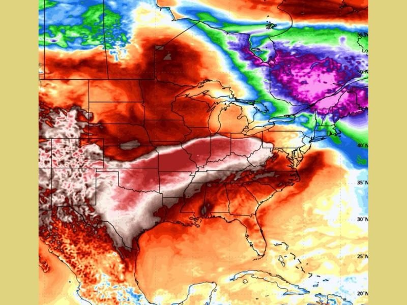
EURO Model Highlights Widespread Warm Anomalies Across the Region
The newest EURO projections indicate a large warm air mass spreading from the Southern Plains to the Southeast, covering millions of residents. Areas within Texas, Oklahoma, and Arkansas are shown at the core of this early warm surge, while Louisiana, Mississippi, Alabama, and Georgia remain under persistent warm and humid conditions.
The model’s temperature anomaly map shows deep red shading, representing strong above-average temperatures, stretching across nearly the entire southern tier. The consistency of these warm signals across several runs adds confidence that Christmas Day may feel more like early autumn than late December.
Holiday Plans May Be Affected by Spring-Like Weather Conditions
If the forecast holds, states across the region may experience mild mornings and unusually warm afternoons on December 25. For residents in Georgia, Alabama, Mississippi, and Florida, humidity may remain elevated, creating a noticeably warm and muggy holiday atmosphere. Many locations could come close to, or even exceed, their historic warm-temperature records for Christmas Day.
In the Carolinas and Tennessee, conditions may also trend significantly warmer than normal, leading to a holiday week characterized by above-normal temperatures instead of seasonal chill. This could influence travel plans, outdoor gatherings, and community events typically shaped around cooler December weather.
Meteorologists Explain the Unusual Temperature Pattern
Experts attribute the warmth to a jet stream pattern that keeps cold Arctic air locked in the northern United States, preventing the South from experiencing typical winter conditions. Without strong cold fronts pushing through, warm Gulf air continues to expand northward, reinforcing the anomaly.
While the EURO model has a reputation for strong temperature swings, the repeated appearance of this warm pattern suggests a high likelihood of an unseasonably warm Southern Christmas unless a late-developing system alters the setup.
What Residents Should Watch in the Coming Days
Forecasters advise monitoring updates to see whether the warm anomaly strengthens, weakens, or shifts. With Christmas approaching, new model runs will clarify whether this significant warm spell will extend across the entire Southern region.
For continued weather updates and developing forecasts, visit NapervilleLocal.com for the latest coverage.

I’ve lived in Naperville long enough to see how quickly our community changes — from new developments downtown to sudden shifts in our Midwest weather. Reporting on Naperville news and daily forecasts gives me the chance to keep neighbors informed about what really matters. My goal is simple: deliver clear, timely updates so you always know what’s happening in our city and what to expect from the skies above.