
Texas, Oklahoma, Arkansas Storm Chances Return Midweek as Dryline and Gulf Moisture Fuel Thunderstorms Near Dallas Fort Worth
UNITED STATES — A familiar spring storm pattern is beginning to take shape across the Southern Plains, with Texas, Oklahoma, and Arkansas expected to see increasing chances for thunderstorms as early April begins. Forecast data continues to point toward a midweek setup that could bring a round of storms into the Dallas–Fort Worth area and surrounding regions.
Pattern Shift Signals Return of Storm Activity
After several days of monitoring, weather models are now aligning on a shift toward a more active pattern. A developing trough across the western United States is expected to push energy eastward, while high pressure shifts away from the Southern Plains.
This combination will open the door for deeper Gulf moisture to surge north into Texas, setting the stage for thunderstorm development.
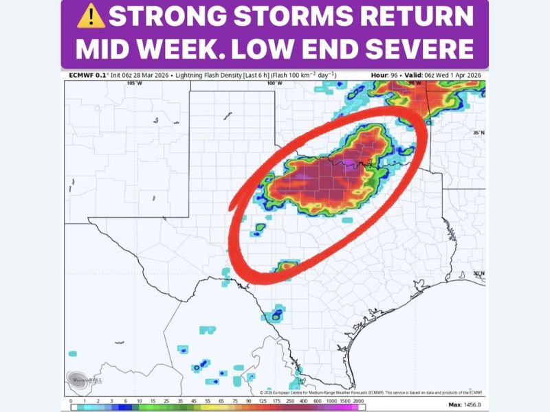
Dryline Setup Becomes Key Trigger Across West Texas
By Tuesday, the dryline—a classic spring feature separating dry desert air from moist Gulf air—will become more active across West Texas.
As an upper-level disturbance approaches, this boundary is expected to spark initial storm development during the late afternoon and evening hours. Storms forming along the dryline could then organize and move eastward.
Storm Line Could Reach Dallas Fort Worth Overnight
Forecast guidance suggests that storms developing Tuesday evening may organize into a line and push into North Texas, including the Dallas–Fort Worth Metroplex, late Tuesday night into early Wednesday morning.
This timing places overnight hours as a key window for impacts in the region.
Primary Threats Include Wind, Hail, and Heavy Rain
At this stage, the severe threat appears to be on the lower end, but still worth monitoring.
The main concerns include:
- Gusty winds
- Small to marginally severe hail
- Frequent lightning
- Localized heavy rainfall
Current atmospheric conditions suggest limited instability, which may keep the overall severe risk marginal, but isolated stronger storms cannot be ruled out.
Start of an Active Early April Pattern
This midweek system may mark the beginning of a more active stretch of weather across North Texas and the Southern Plains. Repeated disturbances and continued moisture flow could lead to multiple rounds of storms through the first week of April.
What This Means Going Forward
Residents across Texas, Oklahoma, and Arkansas should prepare for:
- Increasing storm chances beginning Tuesday
- Potential overnight storms into Wednesday
- Periods of gusty winds, lightning, and heavy rain
- A transition into a more active spring weather pattern
While this first round may not bring widespread severe weather, it signals the return of typical springtime storm activity across the region.
Stay with NapervilleLocal.com for continued coverage, forecast updates, and real-time alerts as this midweek storm system develops across the Southern Plains.

I’ve lived in Naperville long enough to see how quickly our community changes — from new developments downtown to sudden shifts in our Midwest weather. Reporting on Naperville news and daily forecasts gives me the chance to keep neighbors informed about what really matters. My goal is simple: deliver clear, timely updates so you always know what’s happening in our city and what to expect from the skies above.