
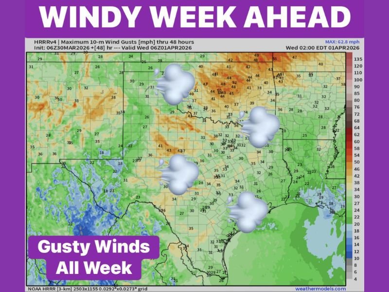
Texas, Oklahoma Face Windy Week Ahead With 30 to 40 MPH Gusts Daily and Peaks Near 50 MPH Across Plains Region
TEXAS, OKLAHOMA — A prolonged stretch of strong winds is expected to impact large parts of Texas and Oklahoma throughout the week, with daily gusts frequently reaching 30 to 40 mph and even higher peaks in some areas.
The pattern signals a consistently breezy to windy setup, making this one of the more active wind periods of the season across the Southern Plains.
Strong Wind Gusts Expected Across Multiple Regions
Forecast data shows widespread wind activity across both states, with much of Texas and Oklahoma experiencing sustained gusty conditions.
Across central and northern Oklahoma, wind gusts are projected to reach 40 to 50 mph, especially during peak daytime heating hours. Meanwhile, large portions of Texas — including central, west, and north Texas — are expected to see frequent gusts between 30 and 40 mph.
Localized areas within Oklahoma may briefly exceed these values, making it the zone with the highest wind potential this week.
Why This Week Will Be Especially Windy
April is historically known as one of the windiest months across the Southern Plains, and current conditions are aligning with that seasonal trend.
A combination of:
- Strong pressure differences across the region
- Warm daytime temperatures
- Open terrain across Texas and Oklahoma
is helping to accelerate wind speeds across a wide area. These factors will remain in place for several consecutive days, preventing winds from calming significantly.
Areas Seeing the Strongest Impacts
The highest wind activity is expected across:
- Northern and central Oklahoma, where gusts may approach 50 mph
- Western and central Texas, where sustained breezy conditions will persist
- Southern Plains corridor, where wind speeds remain elevated across multiple days
Even areas farther south in Texas will still experience steady winds in the 25 to 35 mph range, creating widespread impact rather than isolated events.
Travel and Outdoor Impacts to Watch
With winds remaining strong throughout the week, residents should prepare for ongoing impacts, particularly during afternoon hours when gusts tend to peak.
Potential impacts include:
- Difficult driving conditions for high-profile vehicles
- Blowing dust in open and dry areas
- Minor tree movement and loose outdoor objects being displaced
Outdoor plans may need adjustment, especially in areas where gusts approach or exceed 40 mph.
Extended Wind Pattern Continues Through the Week
Unlike short-lived wind events, this setup is expected to persist for several days, keeping conditions consistently breezy to windy across Texas and Oklahoma.
The repeated nature of these gusts could increase cumulative impacts over time, particularly in areas already experiencing dry conditions. Residents are encouraged to stay aware of daily conditions as this windy pattern continues to evolve across the region. Stay with NapervilleLocal.com for continued weather updates and regional impact coverage.

I’ve lived in Naperville long enough to see how quickly our community changes — from new developments downtown to sudden shifts in our Midwest weather. Reporting on Naperville news and daily forecasts gives me the chance to keep neighbors informed about what really matters. My goal is simple: deliver clear, timely updates so you always know what’s happening in our city and what to expect from the skies above.