
Texas Supercell Produces Massive 4.5-Inch Grapefruit Hail in Real County, Storm Tracks Toward Gillespie, Blanco, and Hays Counties Near Austin
REAL COUNTY, TEXAS — A powerful and long-tracked supercell thunderstorm swept across the Texas Hill Country Tuesday evening, producing massive 4.5-inch “grapefruit-size” hail and triggering multiple tornado warnings as it advanced east toward populated counties near Austin.
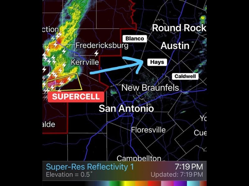
Weather radar around 7:19 p.m. showed the intense storm moving from the western Hill Country toward Gillespie, Blanco, and Hays counties, placing communities across central Texas on alert for dangerous severe weather conditions.
Giant Grapefruit-Size Hail Confirmed in Real County
The storm first gained attention after reports confirmed hail measuring about 4.5 inches in diameter in Real County. Hail of this size is capable of causing extensive damage to vehicles, roofs, and windows while posing a serious risk to anyone caught outdoors.
Radar imagery showed a strong supercell structure west of Kerrville and Fredericksburg, where intense reflectivity and lightning activity indicated powerful updrafts capable of sustaining extremely large hailstones. Meteorologists noted that storms producing hail this large are typically associated with very strong rotating updrafts, a signature feature of severe supercells.
Storm Moving East Toward Gillespie, Blanco, and Hays Counties
As the evening progressed, the storm continued tracking eastward across the Hill Country. Communities including Fredericksburg, Blanco, and areas approaching Hays County were advised to monitor the storm closely as it approached.
The projected path places several heavily traveled areas within the storm’s potential impact zone, including communities north of San Antonio and west of Austin, where strong storms often intensify as they interact with warm and unstable air. Residents in Hays County and surrounding regions were urged to stay weather aware as the storm approached within the next hour or two.
Multiple Tornado Warnings Issued
In addition to producing destructive hail, the supercell has already triggered several tornado warnings during its track across the Hill Country. Long-tracked supercells like this one are closely monitored because they can maintain rotation for extended periods, increasing the likelihood of tornado development as the storm evolves.
Meteorologists watching radar trends noted strong storm organization and persistent rotation signatures as the storm advanced eastward. Because of these factors, weather officials warned residents across the region to ensure they have multiple ways to receive severe weather alerts throughout the evening.
Residents Urged to Monitor Radar and Alerts
With the storm continuing to track toward more populated areas near Austin and central Texas communities, officials emphasized the importance of staying informed as conditions evolve.
Large hail, damaging winds, and the potential for additional tornado warnings remain possible as the supercell moves east through the Hill Country. Residents in Gillespie, Blanco, and Hays counties are encouraged to monitor local weather alerts and take shelter immediately if warnings are issued. Meteorologists will continue tracking the storm closely as it progresses across central Texas, where atmospheric conditions remain favorable for severe weather development through the evening hours.

I’ve lived in Naperville long enough to see how quickly our community changes — from new developments downtown to sudden shifts in our Midwest weather. Reporting on Naperville news and daily forecasts gives me the chance to keep neighbors informed about what really matters. My goal is simple: deliver clear, timely updates so you always know what’s happening in our city and what to expect from the skies above.