
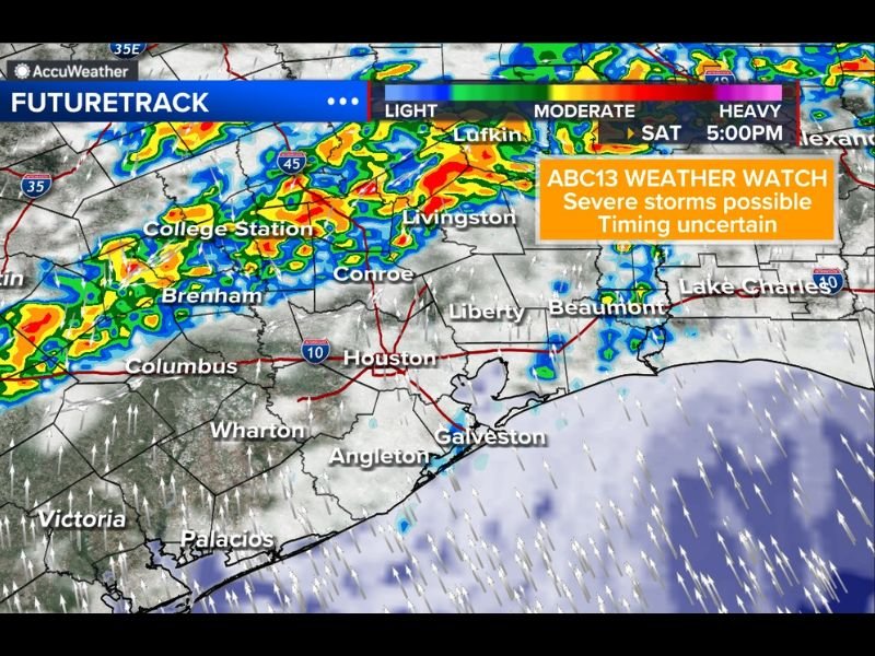
Texas Weather Alert: Houston, Conroe, College Station and Brenham Could See Evening Storms Saturday With Flooding, Hail and Gusty Winds Possible
HOUSTON, TEXAS — Rain chances are returning to southeast Texas this weekend as a line of storms is expected to develop west of Houston on Saturday before gradually moving toward the metro area during the evening hours. Forecasters say the region could see thunderstorms capable of producing street flooding, hail, and strong wind gusts as the system moves across parts of southeast Texas.
Meteorologists say the rainfall is badly needed across the region, but the timing of the storms remains somewhat uncertain as the system approaches the Houston area.
Storms Expected to Develop West of Houston
Weather models indicate that thunderstorms may begin forming Saturday afternoon across parts of central Texas before organizing into a line stretching from areas near Austin and Columbus through Brenham and College Station.
As the system strengthens, it is expected to push eastward toward Conroe, Livingston, and the northern Houston metro area later in the day. The radar projections show bands of moderate to heavy rainfall moving across these areas, potentially creating intense downpours in a short amount of time.
The line of storms could become more organized as it approaches the Interstate 45 corridor, raising concerns about stronger storm cells developing as they move toward the Houston region.
Houston Metro May See Storms in the Evening
Forecasters say storms will likely hold off for much of the daytime hours in Houston, meaning many outdoor activities may remain dry earlier in the day.
However, the storm line is expected to approach the metro area by late afternoon or evening, increasing the risk of thunderstorms across Houston and nearby communities.
Cities including Conroe, Liberty, and areas north of Houston may experience storm activity first before the system gradually spreads toward the rest of the metro area.
Flooding, Hail and Gusty Winds Possible
Some storms in the line could become strong, bringing heavy rain, gusty winds, and isolated hail. Localized street flooding is also possible in areas where downpours become intense, especially in urban areas with poor drainage.
Forecasters say the combination of moisture-rich air and developing storm cells could allow certain storms to briefly intensify as they move across southeast Texas.
While widespread severe weather is not guaranteed, residents should still prepare for rapidly changing conditions once storms begin arriving.
Rain Chances Continue Through the Night and Sunday
The unsettled weather pattern may not end once the initial storms pass through Houston. Rain chances are expected to continue overnight and into parts of Sunday, as lingering moisture keeps showers and thunderstorms possible across the region.
Cities along the upper Texas coast including Galveston and areas near Beaumont may also experience periods of rain as the system gradually moves eastward.
Forecasters say the exact timing of the strongest storms is still being monitored, and updates will continue as the weather pattern becomes clearer. Residents across southeast Texas are encouraged to stay aware of changing forecasts through the weekend as this storm system approaches.

I’ve lived in Naperville long enough to see how quickly our community changes — from new developments downtown to sudden shifts in our Midwest weather. Reporting on Naperville news and daily forecasts gives me the chance to keep neighbors informed about what really matters. My goal is simple: deliver clear, timely updates so you always know what’s happening in our city and what to expect from the skies above.