
Texas Weather Pattern Shifts as Upper-Level Low Pushes Rain North and Snow Into the Big Bend Region
Texas — A developing upper-level low tracking east across northern Mexico is drawing a broad plume of moisture northward into Texas, setting up a multi-day period of unsettled weather beginning tonight and continuing into Tuesday morning. Forecast guidance shows the system remaining well-organized as it moves toward central Texas, increasing confidence in widespread precipitation.
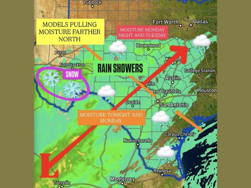
Rain chances will steadily expand northward overnight, marking a notable shift from earlier forecasts that kept most moisture farther south.
Rain Showers Expand Across Central and North Texas
Updated weather models now show rain showers spreading deeper into central Texas, with impacts expected from San Antonio and Austin north toward the Dallas–Fort Worth Metroplex. Moisture is forecast to peak late tonight through Monday, with additional rounds of rain possible into early Tuesday.
While severe weather is not expected, periods of steady rain could lead to wet road conditions, slower travel, and reduced visibility, especially during the morning commute hours.
Snow Expected in the Big Bend at Higher Elevations
Colder air wrapping around the western side of the storm system will support snowfall in far West Texas, particularly across the Big Bend region. Snow levels are expected to drop to around 4,000 feet, with accumulating snow most likely above 5,000 feet.
Lower elevations should remain rain-dominant, but drivers traveling through mountainous areas should be prepared for slick roads and reduced traction, especially overnight.
Why This Weather Setup Is Gaining Attention
Meteorologists are watching this system closely because the upper low is staying intact longer than initially expected, allowing moisture to be pulled farther north across Texas. This increases both rain coverage and duration, especially across central portions of the state.
The setup also highlights a sharp weather contrast, with cool rain in central and eastern Texas while snow impacts remain confined to higher terrain in the west.
What Texans Can Expect Through Tuesday
Rain chances will gradually shift east late Tuesday as the system weakens and exits the region. Until then, residents should plan for cloudy skies, cooler temperatures, and periodic rain, particularly during overnight and morning hours.
Forecasters say confidence is high that this will be a meaningful moisture event for Texas rather than a quick-moving disturbance, with beneficial rainfall expected in many areas. For continued weather coverage, pattern explanations, and clear breakdowns of developing systems across the country, follow NapervilleLocal.com, where we track impactful weather trends and explain why they matter beyond local borders.

I’ve lived in Naperville long enough to see how quickly our community changes — from new developments downtown to sudden shifts in our Midwest weather. Reporting on Naperville news and daily forecasts gives me the chance to keep neighbors informed about what really matters. My goal is simple: deliver clear, timely updates so you always know what’s happening in our city and what to expect from the skies above.