
Thanksgiving Cold Snap to Hit Illinois, Oklahoma, and Texas as Arctic Air Sweeps South by End of November
ILLINOIS — As millions prepare for Thanksgiving travel, forecasters are sounding alarms over a major cold snap expected to sweep across Illinois, Oklahoma, and Texas by the end of November, bringing one of the earliest Arctic blasts of the season.
Meteorologists, including Chief Meteorologist Mike Collier, say the signals for a strong cooldown are growing clearer as cold Arctic air is set to surge deep into the U.S., likely coinciding with the holiday weekend.
Forecasters Confirm Cold Front Likely Around Thanksgiving
Collier explained that long-range data continues to support a sharp drop in temperatures beginning just before or during Thanksgiving week.
“The battle line is being drawn right around Thanksgiving,” Collier said. “This could arrive on or near Thanksgiving, or shift toward the following weekend. But the message stays the same — changes are coming.”
He emphasized that the prediction is based on pattern recognition, where upper-air signals and long-range models align to show a high probability of Arctic air descending from Canada. “These signs appear well before the event,” Collier noted, “giving people time to prepare for major temperature swings.”
The Science Behind the Sudden Temperature Drop
Meteorologists are watching signs of a Sudden Stratospheric Warming (SSW) event — a rare but powerful atmospheric phenomenon.
“When the stratosphere begins to warm rapidly, it can disrupt the polar circulation,” Collier explained. “That allows Arctic air to spill southward.”
This disruption weakens the polar vortex, often unleashing frigid air across the United States. Collier said while these signals don’t guarantee extreme cold by themselves, they serve as early warnings that the atmosphere is “ready to flip.”
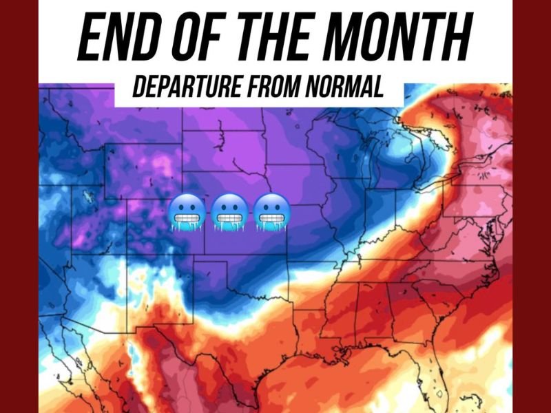
Expected Temperature Impacts Across Key States
Forecast maps shared by Collier and the Generator Supercenter of Tulsa show temperatures well below average across several regions:
- Illinois: Residents should brace for highs in the 30s and 40s with freezing wind chills. Early morning frost and light flurries could develop around Chicago and surrounding suburbs.
- Oklahoma: The state will likely experience lows dipping into the 20s, with strong winds and sharp overnight freezes.
- Texas: Northern parts of the state could see near-freezing mornings, while central and southern Texas will feel an abrupt 20–30°F temperature drop.
- Neighboring Areas: Arkansas, Missouri, and Kansas are also expected to see below-normal temperatures and widespread frost conditions.
Meteorologists warn that this pattern marks the start of winter-like conditions that could persist through early December.
Timing: When Will the Cold Arrive?
The cold surge is expected to develop in stages:
- November 24–26: Arctic air begins pushing south into the central Plains.
- November 27–30: Temperatures drop sharply across Illinois, Oklahoma, and Texas, aligning with Thanksgiving travel days.
- Early December: Reinforcing cold waves may follow, keeping much of the Midwest and southern states below seasonal norms.
“This setup could cause a rapid swing from mild to freezing conditions within 24 hours,” Collier said. “It’s the kind of flip that catches travelers off guard.”
Holiday Travel and Safety Concerns
The timing of the cold blast — arriving just as millions hit the roads and airports for the holiday — could complicate travel plans. Sudden drops in temperature could lead to:
- Black ice and freezing rain in overnight hours.
- Flight delays caused by frost and de-icing operations.
- High energy demand for heating across multiple states.
Officials urge residents to check weather updates frequently, winterize vehicles, and prepare for temperature extremes through the Thanksgiving weekend.
Looking Ahead to Early December
The cold snap may not be a short-lived event. Long-range forecasts suggest that a reinforcing surge of Arctic air could arrive in early December, keeping temperatures low across much of the central and eastern U.S.
“This is shaping up to be the first true winter pattern of the season,” Collier said. “Confidence continues to increase that a meaningful cooldown is headed our way toward the end of the month.”
Meteorologists will continue refining the forecast as more upper-air data becomes available.
Do you think this early cold blast could mark the start of a harsh winter? Share your thoughts and follow more Illinois and Midwest weather updates at NapervilleLocal.com.

I’ve lived in Naperville long enough to see how quickly our community changes — from new developments downtown to sudden shifts in our Midwest weather. Reporting on Naperville news and daily forecasts gives me the chance to keep neighbors informed about what really matters. My goal is simple: deliver clear, timely updates so you always know what’s happening in our city and what to expect from the skies above.