
Thanksgiving Morning Could Bring Light Snow Flurries Across Oklahoma, Arkansas, Kansas, and Missouri
TULSA, OKLAHOMA — Residents across parts of Oklahoma, Arkansas, Kansas, and Missouri could see a few light snow flurries overnight into Thanksgiving morning, according to meteorologists tracking a weak post-frontal disturbance moving through the region.
A strong upper-level wave over Colorado early Wednesday is expected to drift southeast overnight, creating just enough lift in the atmosphere to generate scattered clouds and potential flurries from northeastern Oklahoma into the Ozarks by early Thursday morning.
Areas Under Flurry Watch
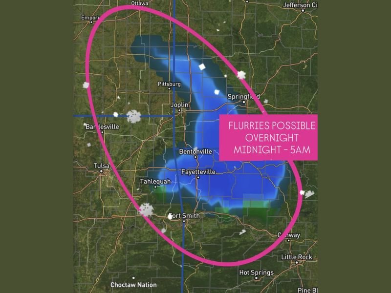
The best chance to spot flakes will be between midnight and 5 a.m., mainly across northeastern Oklahoma, northwest Arkansas, southeastern Kansas, and southwest Missouri. Cities like Tulsa, Fayetteville, Joplin, and Springfield may see a few light snowflakes if conditions align.
However, forecasters stress that this system is limited by dry air — both near the surface and in the mid-levels — which could evaporate most of the precipitation before it reaches the ground.
Dry Air Could Limit Snowfall
Meteorologists say that while the atmospheric lift is in place, moisture levels remain marginal, meaning most areas will only see brief flurries or sprinkles, if anything at all.
“We’re watching a very narrow window,” one weather analyst explained. “If the disturbance pulls just a bit more moisture from the south, some areas could wake up to light flakes on Thanksgiving morning. But it’s going to be spotty.”
The National Weather Service noted that even minor variations in temperature and moisture could influence whether snow makes it to the surface.
Thanksgiving Travel Outlook
Despite the flurry potential, travel conditions are not expected to be impacted, with temperatures hovering near or slightly above freezing and no measurable accumulation forecast. Roads are expected to remain clear.
Still, drivers heading through Fayetteville, Bentonville, and southern Missouri early Thursday are advised to stay alert for brief visibility drops during isolated bursts of snow or mist.
Looking Ahead
The region will remain cold and breezy through Thanksgiving Day, with daytime highs ranging from the 40s to low 50s under mostly cloudy skies. Clearer and calmer weather is expected by Friday as high pressure settles in.
Meteorologists will continue to monitor the system through the night in case additional moisture develops that could make the flurries more widespread.

I’ve lived in Naperville long enough to see how quickly our community changes — from new developments downtown to sudden shifts in our Midwest weather. Reporting on Naperville news and daily forecasts gives me the chance to keep neighbors informed about what really matters. My goal is simple: deliver clear, timely updates so you always know what’s happening in our city and what to expect from the skies above.