
Thanksgiving Week Forecast: Major Arctic Cold Blast Expected to Sweep Across the U.S.
UNITED STATES — Meteorologists are warning that a major Arctic cold blast is expected to hit much of the U.S. during Thanksgiving week, driven by a sudden stratospheric warming event disrupting the polar vortex. The system is forecast to bring dramatic temperature swings, strong winds, and widespread early-season cold across the central and eastern parts of the country.
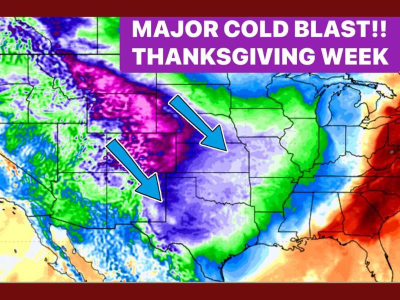
The event is being tracked by long-range forecasting models, which show high confidence in a deep pool of Arctic air forming over northwest Canada and spilling south into the United States just before the holiday.
What’s Behind the Sudden Temperature Shift?
Experts say the anticipated cold wave is linked to a Sudden Stratospheric Warming (SSW) event over the Arctic — a rare meteorological phenomenon in which stratospheric temperatures spike by 30 to 60 degrees Fahrenheit within days.
When this happens, it disrupts the polar vortex, a circulation of strong winds in the upper atmosphere that usually keeps cold air trapped near the North Pole. The disturbance causes that frigid air to shift southward into the mid-latitudes — meaning much of North America could soon feel its effects.
“This pattern is classic for big temperature swings and early-season cold blasts,” forecasters said, noting that the signals for this event have been strengthening in recent model runs.
Timeline: When the Cold Will Arrive
According to forecast data, here’s how the Arctic outbreak is expected to unfold:
- Around November 25: Peak of the sudden stratospheric warming event in the Arctic.
- Late November: Arctic air begins to push into Western Europe, then transitions across the Atlantic.
- Thanksgiving week: The main blast of cold air builds over northwest Canada before shifting southeast toward the U.S.
- Late November into early December: Arctic air surges into the central and eastern United States, dropping temperatures significantly below seasonal averages.
This transition could result in daytime highs 20–30°F below normal in several states, along with wind chills in the teens and single digits in parts of the Midwest and Plains.
What Areas Will Be Most Impacted?
The strongest cold push is expected to affect the central, southern, and eastern regions of the U.S., particularly around and after Thanksgiving:
- Midwest (Illinois, Indiana, Ohio): Highs in the 30s and lows in the 20s expected, with possible light snow or sleet in some areas.
- Central Plains (Kansas, Nebraska, Missouri): Temperatures may plummet 25–35°F below average as Arctic air moves in rapidly.
- South (Texas, Arkansas, Tennessee): Significant cool-down expected, with freezing conditions possible in northern Texas and Tennessee valleys.
- Northeast (New York, Pennsylvania, New England): Temperatures could drop sharply following the Thanksgiving holiday, extending the cold pattern into early December.
Meteorologists say this is one of the earliest widespread Arctic outbreaks of the season, a sign that winter weather patterns are strengthening ahead of schedule.
Travel Impacts and Holiday Concerns
The timing of this cold surge — coinciding with one of the busiest travel weeks of the year — could create hazardous conditions for drivers and air travelers. Sudden temperature drops can lead to:
- Black ice and slippery roads, especially overnight.
- Delayed flights due to de-icing operations and reduced visibility.
- Wind chill advisories for northern and central states.
Officials urge holiday travelers to check forecasts frequently and plan for longer commute times as weather conditions change quickly.
Why Forecasters Are Paying Close Attention
Sudden Stratospheric Warming events are relatively uncommon but have historically been precursors to prolonged cold spells in the Northern Hemisphere.
In this case, the combination of Arctic energy and atmospheric blocking over Canada could lock the cold air in place for several weeks. Meteorologists say the U.S. could experience a colder-than-normal start to December, especially across the Midwest, Great Lakes, and interior Northeast.
“This could be the coldest Thanksgiving stretch in several years,” one forecaster noted, warning that early heating bills could rise as energy demand spikes.
Looking Ahead: Early December Outlook
Following the initial blast, long-range projections show a persistent trough pattern dominating the eastern U.S., meaning additional cold fronts may follow through early December.
Meanwhile, areas in the Southwest and California are expected to remain relatively dry and mild, staying on the warmer side of the jet stream.
Meteorologists will continue to monitor the evolution of the SSW event and its downstream effects on the jet stream in the coming days.
Do you think Thanksgiving travel could be disrupted by the incoming Arctic blast? Share your thoughts and stay updated on Midwest weather at NapervilleLocal.com.

I’ve lived in Naperville long enough to see how quickly our community changes — from new developments downtown to sudden shifts in our Midwest weather. Reporting on Naperville news and daily forecasts gives me the chance to keep neighbors informed about what really matters. My goal is simple: deliver clear, timely updates so you always know what’s happening in our city and what to expect from the skies above.