
Thanksgiving Week Weather Alert: Heavy Snow Risk Expands to Texas and Oklahoma, Midwest Travelers Urged to Prepare
TEXAS — Weather forecasters are tracking a growing threat of heavy snow and hazardous travel conditions across the central United States during Thanksgiving week and weekend, as new models highlight Texas and Oklahoma within a heightened snow risk zone extending north into the Midwest and Great Lakes.
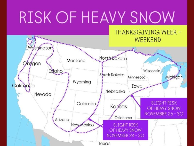
The Climate Prediction Center (CPC) released an experimental long-range outlook showing a slight to moderate risk of heavy snow from November 24 through November 30, a window coinciding with one of the busiest U.S. travel periods of the year.
“Signals are strengthening for a potential winter storm during Thanksgiving week,” forecasters said. “It’s still too early to determine exact timing or amounts, but confidence is rising that parts of the central and western U.S. could experience significant snow impacts.”
Texas and Oklahoma Now in the Snow Risk Zone
According to the CPC’s latest “Risk of Heavy Snow” outlook, the southern Plains — including parts of Texas, Oklahoma, and New Mexico — have now been added to the Thanksgiving week snow watch area.
Meteorologists say this inclusion indicates a strong chance of a cold, moisture-rich system sweeping through the region, capable of dropping several inches of snow and producing travel slowdowns on interstates and air routes.
“This setup could bring rare early-season snow to portions of Texas and Oklahoma,” said one CPC meteorologist. “Even if totals stay light, freezing rain or sleet could be an issue for holiday travelers.”
The risk area also extends northward through Kansas, Colorado, Nebraska, South Dakota, and into the Great Lakes, with the highest potential from November 26–30.
Possible Winter Storm Stretching from the Rockies to the Midwest
While models are still evolving, the early forecast points to a broad winter storm system tracking eastward from the Rocky Mountains around Thanksgiving Day, moving into the Midwest and Great Lakes by the following weekend.
This could bring widespread snow, gusty winds, and dangerous road conditions across multiple states — including Illinois, Iowa, and Wisconsin.
In the CPC’s long-range map, two distinct windows are outlined:
- November 24–30: Slight risk of heavy snow for New Mexico, Texas, and Oklahoma.
- November 26–30: Slight risk for Kansas, Nebraska, South Dakota, and the upper Midwest, including Illinois and Michigan.
If the system strengthens, it could evolve into a multi-day winter storm, similar to the late-November snow events seen in past years that disrupted post-Thanksgiving travel.
“This isn’t a guaranteed storm yet, but travelers should begin factoring in the possibility of winter weather during peak return days,” forecasters noted.
Thanksgiving Travel Could Be Affected Nationwide
The timing of this developing system could make travel difficult for millions heading home after the holiday.
The Federal Aviation Administration (FAA) and major airlines are already monitoring potential impacts to key Midwest hubs, including Chicago O’Hare, Dallas-Fort Worth, and Denver International.
Road conditions could deteriorate quickly if snow bands develop along major highways such as:
- I-35 (Texas to Minnesota)
- I-70 (Colorado to Missouri)
- I-80 (Nebraska to Illinois)
- I-90 (South Dakota to Wisconsin)
Travelers are advised to stay flexible with plans, book earlier flights when possible, and monitor real-time forecasts beginning early next week.
Cold Air and Snow Likely to Persist Through the Holiday Weekend
Meteorologists say this upcoming pattern will be driven by a deep surge of Arctic air moving southward from Canada, meeting Pacific moisture streaming into the central U.S.
The result could be heavy snow bands across the Plains and Midwest and a sharp temperature drop following the front’s passage.
- Temperature Forecast: Highs 15–25°F below normal across much of the central U.S.
- Snow Potential: Early models indicate localized totals of 6–10 inches in higher elevations and open Plains areas.
- Timing: Arctic front enters Rockies by Sunday, Nov. 24, spreading east through Thanksgiving week.
Why This Pattern Is Significant
This storm threat marks the second major early-season cold outbreak in November, following last week’s Arctic blast that plunged much of the country into below-freezing temperatures.
If this system materializes as expected, it could deliver:
- The first measurable snow of the season for parts of Texas and Oklahoma.
- Widespread travel delays on one of the year’s busiest weekends.
- Reinforced cold air through early December, setting the tone for a colder-than-average start to winter.
“The setup is classic for late fall — strong Arctic air colliding with southern moisture,” one NOAA meteorologist explained. “It doesn’t take much to produce impactful snow or ice when those two ingredients align.”
Stay Prepared and Monitor Forecast Updates
Forecasters emphasize that the system’s exact track and strength will become clearer within the next 5–7 days. In the meantime, travelers should:
- Check weather updates daily starting early Thanksgiving week.
- Keep alternate routes or flexible return dates in mind.
- Pack winter essentials — warm clothing, emergency kits, and extra time for driving.
The National Weather Service will issue detailed storm watches or warnings once the system’s path solidifies.
Stay tuned to NapervilleLocal.com for continuous updates on national and Midwest Thanksgiving travel weather alerts.

I’ve lived in Naperville long enough to see how quickly our community changes — from new developments downtown to sudden shifts in our Midwest weather. Reporting on Naperville news and daily forecasts gives me the chance to keep neighbors informed about what really matters. My goal is simple: deliver clear, timely updates so you always know what’s happening in our city and what to expect from the skies above.